

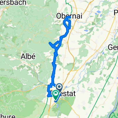
SELESTAT-HOHWALD
A cycling route starting in Sélestat, Grand Est, France.
Overview
About this route
climb via Andlau and return through the Val de Villé
- -:--
- Duration
- 57.4 km
- Distance
- 1,030 m
- Ascent
- 1,021 m
- Descent
- ---
- Avg. speed
- 772 m
- Max. altitude

Route quality
Waytypes & surfaces along the route
Waytypes
Road
20.1 km
(35 %)
Quiet road
8.6 km
(15 %)
Surfaces
Paved
24.7 km
(43 %)
Unpaved
1.1 km
(2 %)
Asphalt
23.5 km
(41 %)
Paved (undefined)
0.6 km
(1 %)
Continue with Bikemap
Use, edit, or download this cycling route
You would like to ride SELESTAT-HOHWALD or customize it for your own trip? Here is what you can do with this Bikemap route:
Free features
- Save this route as favorite or in collections
- Copy & plan your own version of this route
- Sync your route with Garmin or Wahoo
Premium features
Free trial for 3 days, or one-time payment. More about Bikemap Premium.
- Navigate this route on iOS & Android
- Export a GPX / KML file of this route
- Create your custom printout (try it for free)
- Download this route for offline navigation
Discover more Premium features.
Get Bikemap PremiumFrom our community
Other popular routes starting in Sélestat
 Rue St-Léonard, Sélestat à Route de Colmar, Sélestat
- Distance
- 77.5 km
- Ascent
- 761 m
- Descent
- 767 m
- Location
- Sélestat, Grand Est, France
 Rue du Champ de Mars 11b, Sélestat to Rue du Péage du Roi 11, Sélestat
- Distance
- 15.2 km
- Ascent
- 78 m
- Descent
- 81 m
- Location
- Sélestat, Grand Est, France
 Sélestat 31 km VTT plaine
- Distance
- 31.5 km
- Ascent
- 80 m
- Descent
- 82 m
- Location
- Sélestat, Grand Est, France
 2012 French Tour -- Ride Day 22 -- 2 September 2012 -- Sélestat to Climbach
- Distance
- 118.9 km
- Ascent
- 471 m
- Descent
- 286 m
- Location
- Sélestat, Grand Est, France
 Selestat 3
- Distance
- 57.2 km
- Ascent
- 277 m
- Descent
- 277 m
- Location
- Sélestat, Grand Est, France
 Selestat-Steige
- Distance
- 27.6 km
- Ascent
- 572 m
- Descent
- 390 m
- Location
- Sélestat, Grand Est, France
 Sélestat-Obernai-Strasbourg
- Distance
- 67.7 km
- Ascent
- 269 m
- Descent
- 300 m
- Location
- Sélestat, Grand Est, France
 Selestat 10
- Distance
- 54.3 km
- Ascent
- 350 m
- Descent
- 349 m
- Location
- Sélestat, Grand Est, France
Open it in the app