
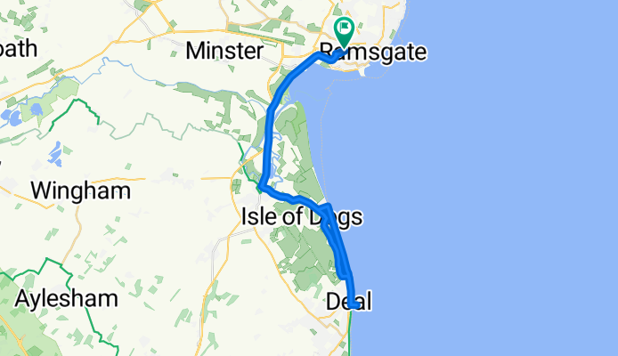
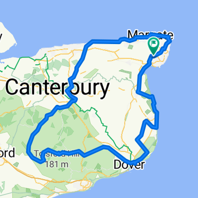
Ramsgate Deal Ramsgate
A cycling route starting in Ramsgate, England, United Kingdom.
Overview
About this route
- 1 h 41 min
- Duration
- 36.2 km
- Distance
- 75 m
- Ascent
- 122 m
- Descent
- 21.6 km/h
- Avg. speed
- 91 m
- Max. altitude

Route photos


Route quality
Waytypes & surfaces along the route
Waytypes
Cycleway
16.1 km
(45 %)
Quiet road
11.2 km
(31 %)
Surfaces
Paved
29.8 km
(82 %)
Unpaved
2.5 km
(7 %)
Asphalt
27.1 km
(75 %)
Ground
2.5 km
(7 %)
Continue with Bikemap
Use, edit, or download this cycling route
You would like to ride Ramsgate Deal Ramsgate or customize it for your own trip? Here is what you can do with this Bikemap route:
Free features
- Save this route as favorite or in collections
- Copy & plan your own version of this route
- Sync your route with Garmin or Wahoo
Premium features
Free trial for 3 days, or one-time payment. More about Bikemap Premium.
- Navigate this route on iOS & Android
- Export a GPX / KML file of this route
- Create your custom printout (try it for free)
- Download this route for offline navigation
Discover more Premium features.
Get Bikemap PremiumFrom our community
Other popular routes starting in Ramsgate
 25mile loop
- Distance
- 43.1 km
- Ascent
- 130 m
- Descent
- 129 m
- Location
- Ramsgate, England, United Kingdom
 27 Crescent Road, Ramsgate to 29 Grove Road, Ramsgate
- Distance
- 21 km
- Ascent
- 6 m
- Descent
- 26 m
- Location
- Ramsgate, England, United Kingdom
 Royal Sands Apartments, Marina Esplanade, Thanet to 26 Belmont Road, Broadstairs
- Distance
- 6.6 km
- Ascent
- 94 m
- Descent
- 64 m
- Location
- Ramsgate, England, United Kingdom
 WEstwood/Kingsgate/Margate
- Distance
- 19.8 km
- Ascent
- 98 m
- Descent
- 98 m
- Location
- Ramsgate, England, United Kingdom
 Ramsgate Station, Station Approach Road, Ramsgate to Tulse Hill Railway Station, Station Rise, London
- Distance
- 148.7 km
- Ascent
- 999 m
- Descent
- 1,000 m
- Location
- Ramsgate, England, United Kingdom
 ramsgate round trip
- Distance
- 132 km
- Ascent
- 486 m
- Descent
- 486 m
- Location
- Ramsgate, England, United Kingdom
 Vikings and Spitfires
- Distance
- 25.3 km
- Ascent
- 168 m
- Descent
- 166 m
- Location
- Ramsgate, England, United Kingdom
- Ramsgate Deal Ramsgate
- Distance
- 36.2 km
- Ascent
- 75 m
- Descent
- 122 m
- Location
- Ramsgate, England, United Kingdom
Open it in the app