
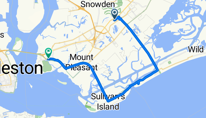
Belk Drive to Coleman Blvd / Patriots Point Rd
A cycling route starting in Mt. Pleasant, South Carolina, United States of America.
Overview
About this route
- 2 h 27 min
- Duration
- 22.1 km
- Distance
- 338 m
- Ascent
- 315 m
- Descent
- 9 km/h
- Avg. speed
- 31 m
- Max. altitude

Route photos


Continue with Bikemap
Use, edit, or download this cycling route
You would like to ride Belk Drive to Coleman Blvd / Patriots Point Rd or customize it for your own trip? Here is what you can do with this Bikemap route:
Free features
- Save this route as favorite or in collections
- Copy & plan your own version of this route
- Sync your route with Garmin or Wahoo
Premium features
Free trial for 3 days, or one-time payment. More about Bikemap Premium.
- Navigate this route on iOS & Android
- Export a GPX / KML file of this route
- Create your custom printout (try it for free)
- Download this route for offline navigation
Discover more Premium features.
Get Bikemap PremiumFrom our community
Other popular routes starting in Mt. Pleasant
 Route from 940 Equestrian Dr, Mount Pleasant
- Distance
- 6.7 km
- Ascent
- 29 m
- Descent
- 39 m
- Location
- Mt. Pleasant, South Carolina, United States of America
 Sullivan's Island to County Park Route
- Distance
- 32 km
- Ascent
- 56 m
- Descent
- 56 m
- Location
- Mt. Pleasant, South Carolina, United States of America
 1025 Rifle Range Rd, Mount Pleasant to 2210 Middle St, Sullivans Island
- Distance
- 4.2 km
- Ascent
- 6 m
- Descent
- 7 m
- Location
- Mt. Pleasant, South Carolina, United States of America
- Belk Drive to Coleman Blvd / Patriots Point Rd
- Distance
- 22.1 km
- Ascent
- 338 m
- Descent
- 315 m
- Location
- Mt. Pleasant, South Carolina, United States of America
 trial
trial- Distance
- 18.1 km
- Ascent
- 64 m
- Descent
- 31 m
- Location
- Mt. Pleasant, South Carolina, United States of America
 U.S. 17 1485, Mount Pleasant to Appling Drive 1240, Mount Pleasant
- Distance
- 10.2 km
- Ascent
- 16 m
- Descent
- 21 m
- Location
- Mt. Pleasant, South Carolina, United States of America
 18 Isle of Hope, Mount Pleasant to 2403 Mall Dr, North Charleston
- Distance
- 30.3 km
- Ascent
- 426 m
- Descent
- 420 m
- Location
- Mt. Pleasant, South Carolina, United States of America
 15.5-16 mile loop Sullivan's
- Distance
- 25.4 km
- Ascent
- 20 m
- Descent
- 18 m
- Location
- Mt. Pleasant, South Carolina, United States of America
Open it in the app