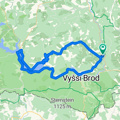
Etapa 050C (Vyšší Brod - Grein)
A cycling route starting in Vyšší Brod, Jihočeský kraj, Czechia.
Overview
About this route
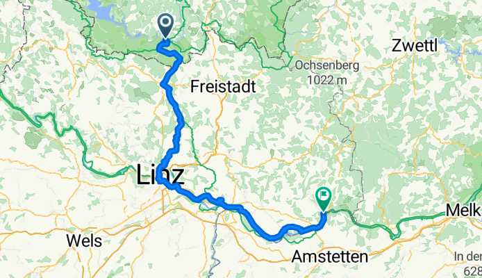
Western Europe Tour. Stage 50
Vyšší Brod - AUSTRIA - Bad Leonfelden - Reichenau im Mühlkreis - Altenberg bei Linz - Linz - Sankt Georgen an der Gusen - Gusen - Langenstein - Au an der Donau - Grein
116.5 km
1340 m total positive elevation gain
- 7 h 6 min
- Duration
- 116.3 km
- Distance
- 1,336 m
- Ascent
- 1,668 m
- Descent
- 16.4 km/h
- Avg. speed
- 802 m
- Max. altitude
Route quality
Waytypes & surfaces along the route
Waytypes
Road
37.2 km
(32 %)
Quiet road
26.7 km
(23 %)
Surfaces
Paved
90.7 km
(78 %)
Unpaved
7 km
(6 %)
Asphalt
90.7 km
(78 %)
Gravel
5.8 km
(5 %)
Route highlights
Points of interest along the route
Point of interest after 57 km
KZ-Gedenkstätte Gusen
Point of interest after 115.8 km
ltes Rathaus / Magistrat Linz
Point of interest after 115.8 km
Schlossmuseum Linz
Point of interest after 115.8 km
Linzer Mariendom
Point of interest after 115.8 km
Alter Dom - Ignatiuskirche
Point of interest after 115.8 km
Hauptplatz Linz
Point of interest after 115.8 km
Mozarthaus
Continue with Bikemap
Use, edit, or download this cycling route
You would like to ride Etapa 050C (Vyšší Brod - Grein) or customize it for your own trip? Here is what you can do with this Bikemap route:
Free features
- Save this route as favorite or in collections
- Copy & plan your own version of this route
- Split it into stages to create a multi-day tour
- Sync your route with Garmin or Wahoo
Premium features
Free trial for 3 days, or one-time payment. More about Bikemap Premium.
- Navigate this route on iOS & Android
- Export a GPX / KML file of this route
- Create your custom printout (try it for free)
- Download this route for offline navigation
Discover more Premium features.
Get Bikemap PremiumFrom our community
Other popular routes starting in Vyšší Brod
Pohraniční stráže, Vyšší Brod - Silnice 1636, Horní Planá- Distance
- 43.6 km
- Ascent
- 856 m
- Descent
- 708 m
- Location
- Vyšší Brod, Jihočeský kraj, Czechia
Vyšší Brod-Innsbruck-Benátky(1.část)- Distance
- 439.8 km
- Ascent
- 707 m
- Descent
- 692 m
- Location
- Vyšší Brod, Jihočeský kraj, Czechia
2012_Dresden - Passau, Teil 7- Distance
- 48.5 km
- Ascent
- 506 m
- Descent
- 315 m
- Location
- Vyšší Brod, Jihočeský kraj, Czechia
Etapa 050C (Vyšší Brod - Grein)- Distance
- 116.3 km
- Ascent
- 1,336 m
- Descent
- 1,668 m
- Location
- Vyšší Brod, Jihočeský kraj, Czechia
Pohraniční stráže, Vyšší Brod - Rožmberk nad Vltavou, Rožmberk nad Vltavou- Distance
- 30.9 km
- Ascent
- 798 m
- Descent
- 843 m
- Location
- Vyšší Brod, Jihočeský kraj, Czechia
20.7.-Vyšší Brod-Rozmberg-Rozmital-Cesky kr.-Zlatá Koruna 4:09hod-11,4km/hod-58,9max- Distance
- 48 km
- Ascent
- 1,043 m
- Descent
- 1,148 m
- Location
- Vyšší Brod, Jihočeský kraj, Czechia
Vyssi brod - Frymburk - Vyssi brod- Distance
- 38.4 km
- Ascent
- 529 m
- Descent
- 532 m
- Location
- Vyšší Brod, Jihočeský kraj, Czechia
2020. Dél-Csehország Rozmberk-Cesky Budejovice- Distance
- 51.7 km
- Ascent
- 273 m
- Descent
- 430 m
- Location
- Vyšší Brod, Jihočeský kraj, Czechia
Open it in the app


