
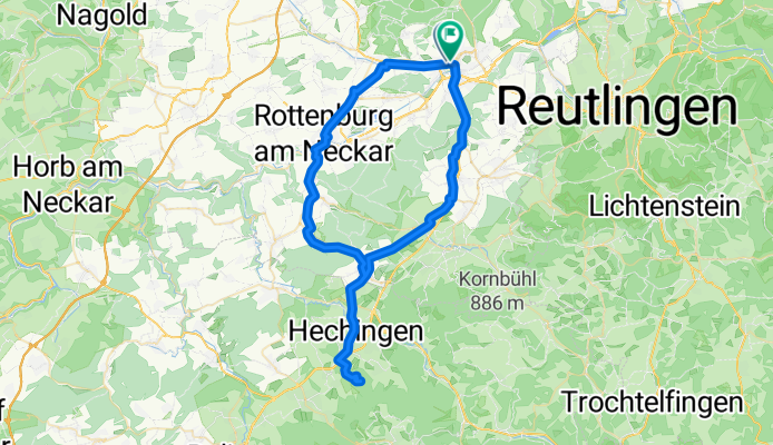
Hohenzollern Bike Trip
A cycling route starting in Tübingen, Baden-Wurttemberg, Germany.
Overview
About this route
- 4 h 16 min
- Duration
- 69.3 km
- Distance
- 955 m
- Ascent
- 954 m
- Descent
- 16.3 km/h
- Avg. speed
- 822 m
- Max. altitude

Route quality
Waytypes & surfaces along the route
Waytypes
Quiet road
22.2 km
(32 %)
Track
18.7 km
(27 %)
Surfaces
Paved
60.3 km
(87 %)
Unpaved
2.1 km
(3 %)
Asphalt
60.3 km
(87 %)
Gravel
1.4 km
(2 %)
Continue with Bikemap
Use, edit, or download this cycling route
You would like to ride Hohenzollern Bike Trip or customize it for your own trip? Here is what you can do with this Bikemap route:
Free features
- Save this route as favorite or in collections
- Copy & plan your own version of this route
- Sync your route with Garmin or Wahoo
Premium features
Free trial for 3 days, or one-time payment. More about Bikemap Premium.
- Navigate this route on iOS & Android
- Export a GPX / KML file of this route
- Create your custom printout (try it for free)
- Download this route for offline navigation
Discover more Premium features.
Get Bikemap PremiumFrom our community
Other popular routes starting in Tübingen
 Radrunde von Tübingen nach Hechingen
- Distance
- 23 km
- Ascent
- 429 m
- Descent
- 140 m
- Location
- Tübingen, Baden-Wurttemberg, Germany
 2017-02-03-H-Hirsch-REWE-Markt-CoBa-Alnatura-Hirsch-A
- Distance
- 13.2 km
- Ascent
- 147 m
- Descent
- 149 m
- Location
- Tübingen, Baden-Wurttemberg, Germany
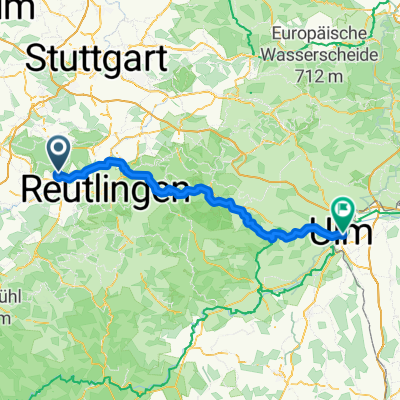 Tübingen to Ulm via Blaubeuren
- Distance
- 99.1 km
- Ascent
- 1,568 m
- Descent
- 1,543 m
- Location
- Tübingen, Baden-Wurttemberg, Germany
 Tübingen - Joggingrunde für Mama und Papa
- Distance
- 15.1 km
- Ascent
- 320 m
- Descent
- 321 m
- Location
- Tübingen, Baden-Wurttemberg, Germany
 Hohenzollern Bike Trip
- Distance
- 69.3 km
- Ascent
- 955 m
- Descent
- 954 m
- Location
- Tübingen, Baden-Wurttemberg, Germany
 kleine Bebenhäuser Runde...
- Distance
- 18.6 km
- Ascent
- 275 m
- Descent
- 201 m
- Location
- Tübingen, Baden-Wurttemberg, Germany
 T Ruine Mundeck und mehr
- Distance
- 47.9 km
- Ascent
- 589 m
- Descent
- 598 m
- Location
- Tübingen, Baden-Wurttemberg, Germany
 MTB-Tour Heuberger Tor - Ruine Müneck
- Distance
- 27.4 km
- Ascent
- 300 m
- Descent
- 303 m
- Location
- Tübingen, Baden-Wurttemberg, Germany
Open it in the app