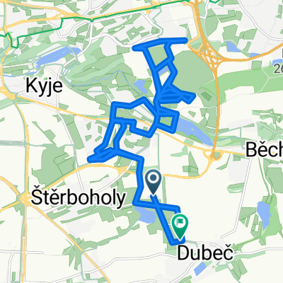
Mezi potoky, Praha 15 do Mezi potoky, Praha 15
- 34.3 km
- 275 m
- 273 m
- Dolní Počernice, Prague, Czechia
A cycling route starting in Dolní Počernice, Prague, Czechia.
Overview
created this 5 months ago


Route quality
Quiet road
10.3 km
(30 %)
Cycleway
10 km
(29 %)
Paved
29.5 km
(86 %)
Unpaved
1.4 km
(4 %)
Asphalt
28.8 km
(84 %)
Concrete
0.7 km
(2 %)
Continue with Bikemap
You would like to ride Mezi potoky, Praha 15 do Mezi potoky, Praha 15 or customize it for your own trip? Here is what you can do with this Bikemap route:
Free trial for 3 days, or one-time payment. More about Bikemap Premium.
Discover more Premium features.
Get Bikemap PremiumFrom our community
Open it in the app