
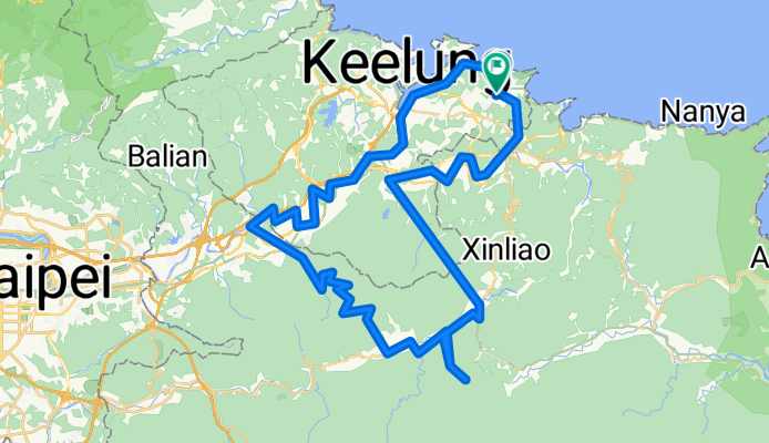
2022-04-17 09:40:42 單車平溪灰窯瀑布繞行基隆河自行車道
A cycling route starting in Keelung, Taiwan, Taiwan.
Overview
About this route
開始時間: 09:39 2022年4月17日結束時間: 16:23 2022年4月17日距離: 80.5 km (06:44)移動時間: 04:42平均速度: 11.94 km/h平均移動速度: 17.09 km/h最大速度: 38.93 km/h最低海拔: -44 m最高海拔: 470 m上升速度: 564.4 m/h下降速度: 964.6 m/h高度上升: 1003 m高度下降: 991 m上升時間: 01:46下降時間: 01:01
- -:--
- Duration
- 95.2 km
- Distance
- 2,330 m
- Ascent
- 2,326 m
- Descent
- ---
- Avg. speed
- 542 m
- Max. altitude

Route photos


Continue with Bikemap
Use, edit, or download this cycling route
You would like to ride 2022-04-17 09:40:42 單車平溪灰窯瀑布繞行基隆河自行車道 or customize it for your own trip? Here is what you can do with this Bikemap route:
Free features
- Save this route as favorite or in collections
- Copy & plan your own version of this route
- Split it into stages to create a multi-day tour
- Sync your route with Garmin or Wahoo
Premium features
Free trial for 3 days, or one-time payment. More about Bikemap Premium.
- Navigate this route on iOS & Android
- Export a GPX / KML file of this route
- Create your custom printout (try it for free)
- Download this route for offline navigation
Discover more Premium features.
Get Bikemap PremiumFrom our community
Other popular routes starting in Keelung
- 2022-04-17 09:40:42 單車平溪灰窯瀑布繞行基隆河自行車道
- Distance
- 95.2 km
- Ascent
- 2,330 m
- Descent
- 2,326 m
- Location
- Keelung, Taiwan, Taiwan
 汐止-福隆
汐止-福隆- Distance
- 45.2 km
- Ascent
- 1,157 m
- Descent
- 1,190 m
- Location
- Keelung, Taiwan, Taiwan
 基隆鳶飛百客固定夜騎-星期一大坪國小
- Distance
- 21.8 km
- Ascent
- 541 m
- Descent
- 467 m
- Location
- Keelung, Taiwan, Taiwan
 友蚋溪谷
友蚋溪谷- Distance
- 20.8 km
- Ascent
- 855 m
- Descent
- 314 m
- Location
- Keelung, Taiwan, Taiwan
 Bikemania _cycling around Formosa 09
- Distance
- 1,065.6 km
- Ascent
- 1,492 m
- Descent
- 1,592 m
- Location
- Keelung, Taiwan, Taiwan
 Project S
- Distance
- 1,136.3 km
- Ascent
- 1,682 m
- Descent
- 1,655 m
- Location
- Keelung, Taiwan, Taiwan
 Project S
- Distance
- 1,072.3 km
- Ascent
- 1,763 m
- Descent
- 1,721 m
- Location
- Keelung, Taiwan, Taiwan
 一日東雙塔/瑞芳車站-三貂角燈塔-鵝巒鼻燈塔
- Distance
- 502.9 km
- Ascent
- 1,436 m
- Descent
- 1,456 m
- Location
- Keelung, Taiwan, Taiwan
Open it in the app