

Traininsgtour für Mountaibike
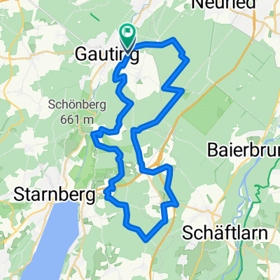
A cycling route starting in Gauting, Bavaria, Germany.
Overview
About this route
In Gauting, through the forest to Leutstetten, with a magnificent view of the mountains
- -:--
- Duration
- 13.1 km
- Distance
- 195 m
- Ascent
- 197 m
- Descent
- ---
- Avg. speed
- ---
- Max. altitude
Route highlights
Points of interest along the route
Point of interest after 6.8 km
Coole Aussicht zu den Bergen
Continue with Bikemap
Use, edit, or download this cycling route
You would like to ride Traininsgtour für Mountaibike or customize it for your own trip? Here is what you can do with this Bikemap route:
Free features
- Save this route as favorite or in collections
- Copy & plan your own version of this route
- Sync your route with Garmin or Wahoo
Premium features
Free trial for 3 days, or one-time payment. More about Bikemap Premium.
- Navigate this route on iOS & Android
- Export a GPX / KML file of this route
- Create your custom printout (try it for free)
- Download this route for offline navigation
Discover more Premium features.
Get Bikemap PremiumFrom our community
Other popular routes starting in Gauting
 MTB Maisinger See
- Distance
- 38.8 km
- Ascent
- 267 m
- Descent
- 269 m
- Location
- Gauting, Bavaria, Germany
 Gauting - Icking
- Distance
- 56.8 km
- Ascent
- 305 m
- Descent
- 305 m
- Location
- Gauting, Bavaria, Germany
 Würmtal
- Distance
- 8.5 km
- Ascent
- 142 m
- Descent
- 202 m
- Location
- Gauting, Bavaria, Germany
 Gauting-63km-21
- Distance
- 62.2 km
- Ascent
- 640 m
- Descent
- 638 m
- Location
- Gauting, Bavaria, Germany
 Bike to work!
- Distance
- 13.3 km
- Ascent
- 4 m
- Descent
- 57 m
- Location
- Gauting, Bavaria, Germany
 37km Neufarn
- Distance
- 37.2 km
- Ascent
- 419 m
- Descent
- 420 m
- Location
- Gauting, Bavaria, Germany
 Gautinger Kultour Nord
- Distance
- 39.8 km
- Ascent
- 67 m
- Descent
- 67 m
- Location
- Gauting, Bavaria, Germany
 Zeitungen 2
- Distance
- 5.9 km
- Ascent
- 7 m
- Descent
- 3 m
- Location
- Gauting, Bavaria, Germany
Open it in the app