![유방동 1029-9Ph0]으로 라우팅](/_next/static/media/contour-lines-light-small.cafd5e5d.avif)
![유방동 1029-9Ph0]으로 라우팅](https://media.bikemap.net/routes/17049104/staticmaps/in_705b9228-50e9-48ef-bbcc-bde5f6e314bc_694x400_bikemap-2021-3D-static.png)
유방동 1029-9Ph0]으로 라우팅
A cycling route starting in Osan, Gyeonggi-do, South Korea.
Overview
About this route
- 53 min
- Duration
- 14.6 km
- Distance
- 53 m
- Ascent
- 97 m
- Descent
- 16.4 km/h
- Avg. speed
- 124 m
- Max. altitude

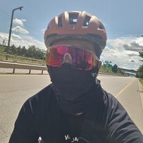
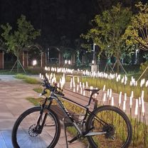
Route photos
![Photo 1 of the Bikemap route "유방동 1029-9Ph0]으로 라우팅"](https://www.bikemap.net/media/temp/routes_gallery/52a48356-cc6f-409b-820a-7369455c91f3.jpg "Photo 1 of the Bikemap route \"유방동 1029-9Ph0]으로 라우팅\"")
![Photo 2 of the Bikemap route "유방동 1029-9Ph0]으로 라우팅"](https://www.bikemap.net/media/temp/routes_gallery/b7856014-78e6-4c24-b09e-f55296eacf2d.jpg "Photo 2 of the Bikemap route \"유방동 1029-9Ph0]으로 라우팅\"")
Continue with Bikemap
Use, edit, or download this cycling route
You would like to ride 유방동 1029-9Ph0]으로 라우팅 or customize it for your own trip? Here is what you can do with this Bikemap route:
Free features
- Save this route as favorite or in collections
- Copy & plan your own version of this route
- Sync your route with Garmin or Wahoo
Premium features
Free trial for 3 days, or one-time payment. More about Bikemap Premium.
- Navigate this route on iOS & Android
- Export a GPX / KML file of this route
- Create your custom printout (try it for free)
- Download this route for offline navigation
Discover more Premium features.
Get Bikemap PremiumFrom our community
Other popular routes starting in Osan
 with chanhoo
- Distance
- 57.5 km
- Ascent
- 308 m
- Descent
- 360 m
- Location
- Osan, Gyeonggi-do, South Korea
- 유방동 1029-9Ph0]으로 라우팅
- Distance
- 14.6 km
- Ascent
- 53 m
- Descent
- 97 m
- Location
- Osan, Gyeonggi-do, South Korea
 오산동 ~ 오산동
- Distance
- 42.7 km
- Ascent
- 259 m
- Descent
- 284 m
- Location
- Osan, Gyeonggi-do, South Korea
 방교동, 화성시에서 동부대로, 화성시까지
- Distance
- 3.6 km
- Ascent
- 31 m
- Descent
- 23 m
- Location
- Osan, Gyeonggi-do, South Korea
![Ph0]에서 경로B140호 393-20](https://media.bikemap.net/routes/17604210/gallery/thumbs/defd9bcd-af53-4ff5-b60a-f9971498acc8.jpg.208x208_q80_crop.jpg) Ph0]에서 경로B140호 393-20
Ph0]에서 경로B140호 393-20- Distance
- 33.2 km
- Ascent
- 243 m
- Descent
- 219 m
- Location
- Osan, Gyeonggi-do, South Korea
 안정적인 라이딩
- Distance
- 14.7 km
- Ascent
- 34 m
- Descent
- 63 m
- Location
- Osan, Gyeonggi-do, South Korea
![롯데캐슬.호반베르디움Ph0]으로 라우팅](https://media.bikemap.net/routes/17273074/gallery/thumbs/5ea4c6d7-d8a7-42a6-8a26-ca91c44eae3a.jpg.208x208_q80_crop.jpg) 롯데캐슬.호반베르디움Ph0]으로 라우팅
롯데캐슬.호반베르디움Ph0]으로 라우팅- Distance
- 9 km
- Ascent
- 508 m
- Descent
- 529 m
- Location
- Osan, Gyeonggi-do, South Korea
 393-20 393-20 ~ 오산동
- Distance
- 29.7 km
- Ascent
- 176 m
- Descent
- 153 m
- Location
- Osan, Gyeonggi-do, South Korea
Open it in the app