
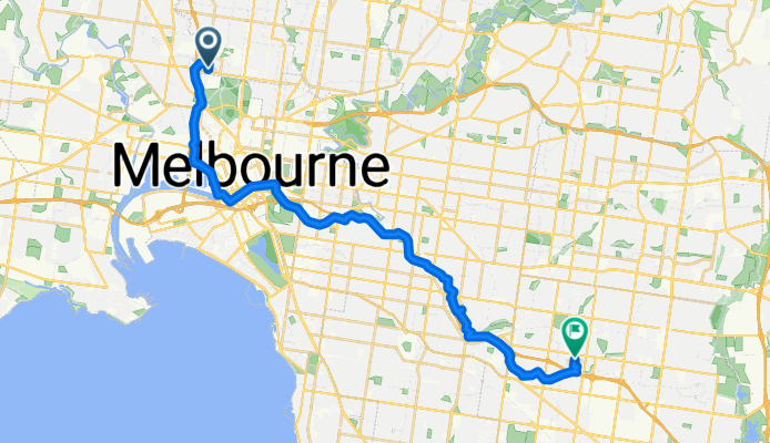
Guthrie Street to Mum's
A cycling route starting in Travancore, Victoria, Australia.
Overview
About this route
- 1 h 50 min
- Duration
- 31.4 km
- Distance
- 263 m
- Ascent
- 200 m
- Descent
- 17.1 km/h
- Avg. speed
- 103 m
- Max. altitude

Route quality
Waytypes & surfaces along the route
Waytypes
Cycleway
29.2 km
(93 %)
Quiet road
1.6 km
(5 %)
Surfaces
Paved
30.2 km
(96 %)
Asphalt
15.7 km
(50 %)
Concrete
10.4 km
(33 %)
Continue with Bikemap
Use, edit, or download this cycling route
You would like to ride Guthrie Street to Mum's or customize it for your own trip? Here is what you can do with this Bikemap route:
Free features
- Save this route as favorite or in collections
- Copy & plan your own version of this route
- Sync your route with Garmin or Wahoo
Premium features
Free trial for 3 days, or one-time payment. More about Bikemap Premium.
- Navigate this route on iOS & Android
- Export a GPX / KML file of this route
- Create your custom printout (try it for free)
- Download this route for offline navigation
Discover more Premium features.
Get Bikemap PremiumFrom our community
Other popular routes starting in Travancore
 Galada Av, Parkville to Galada Av, Parkville
- Distance
- 10.1 km
- Ascent
- 127 m
- Descent
- 130 m
- Location
- Travancore, Victoria, Australia
 Hobsons Bay - Skeletons Creek - Federation Trail- Western Ring Road - Moonee Ponds Creek - Footscray Rd
- Distance
- 92.5 km
- Ascent
- 435 m
- Descent
- 435 m
- Location
- Travancore, Victoria, Australia
 Ride 4
- Distance
- 23.5 km
- Ascent
- 500 m
- Descent
- 491 m
- Location
- Travancore, Victoria, Australia
 Supersonic route in Parkville
- Distance
- 29.7 km
- Ascent
- 536 m
- Descent
- 530 m
- Location
- Travancore, Victoria, Australia
 Ride 2
- Distance
- 17.1 km
- Ascent
- 332 m
- Descent
- 327 m
- Location
- Travancore, Victoria, Australia
 Capital City Trail
- Distance
- 33.5 km
- Ascent
- 89 m
- Descent
- 87 m
- Location
- Travancore, Victoria, Australia
 Bay west, Altona, Federation Taril
- Distance
- 67.8 km
- Ascent
- 61 m
- Descent
- 63 m
- Location
- Travancore, Victoria, Australia
 to speech thrp Moonee
- Distance
- 1.9 km
- Ascent
- 80 m
- Descent
- 43 m
- Location
- Travancore, Victoria, Australia
Open it in the app