
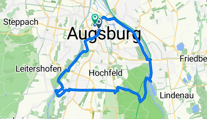
Rundweg Wertach-Lech von Augsburg Süd
A cycling route starting in Augsburg, Bavaria, Germany.
Overview
About this route
Eine schöne Radtour entlang der Augsburger Flüsse Lech und Wertach. Zunächst entlang der Wertach durch das Stadtgebiet Augsburg auf Rad- und Fußwegen. Schöne kleine Stelle direkt am Zusammenfluß von Lech und Wertach. Über Gersthofen zum Auenhof mit Verpflegungsmöglichkeit. Über die Hammerschmiede zurück an den Lech und über den Siebentischwald zurück nach Augsburg Süd.
Hinweis: der Lechweg ist vor allem am Sonntag Nachmittig bei schönem Wetter mit vielen Fußgängern bevölkert.
- 1 h 25 min
- Duration
- 23 km
- Distance
- 104 m
- Ascent
- 106 m
- Descent
- 16.2 km/h
- Avg. speed
- 505 m
- Max. altitude
Route photos


Route quality
Waytypes & surfaces along the route
Waytypes
Path
10.1 km
(44 %)
Quiet road
4.6 km
(20 %)
Surfaces
Paved
17.9 km
(78 %)
Unpaved
4.6 km
(20 %)
Asphalt
17.7 km
(77 %)
Loose gravel
2.1 km
(9 %)
Continue with Bikemap
Use, edit, or download this cycling route
You would like to ride Rundweg Wertach-Lech von Augsburg Süd or customize it for your own trip? Here is what you can do with this Bikemap route:
Free features
- Save this route as favorite or in collections
- Copy & plan your own version of this route
- Sync your route with Garmin or Wahoo
Premium features
Free trial for 3 days, or one-time payment. More about Bikemap Premium.
- Navigate this route on iOS & Android
- Export a GPX / KML file of this route
- Create your custom printout (try it for free)
- Download this route for offline navigation
Discover more Premium features.
Get Bikemap PremiumFrom our community
Other popular routes starting in Augsburg
 Augsburg-Landsberg-Augsburg
- Distance
- 90.4 km
- Ascent
- 195 m
- Descent
- 194 m
- Location
- Augsburg, Bavaria, Germany
 Wertach ab Thelottviertel bis Stausee
- Distance
- 24.8 km
- Ascent
- 137 m
- Descent
- 136 m
- Location
- Augsburg, Bavaria, Germany
 Augsburg - Westliche Wälder und zurück
- Distance
- 31.3 km
- Ascent
- 444 m
- Descent
- 467 m
- Location
- Augsburg, Bavaria, Germany
 Via Claudia NEIL
- Distance
- 577.1 km
- Ascent
- 2,055 m
- Descent
- 2,544 m
- Location
- Augsburg, Bavaria, Germany
 Idyllisches Anhauser Tal – Bismarckturm Neusäß Runde von Augsburg Hauptbahnhof - Idyllisches Anhauser Tal – Bismarckturm Neusäß Runde von Augsburg Hauptbahnhof
- Distance
- 63.3 km
- Ascent
- 339 m
- Descent
- 337 m
- Location
- Augsburg, Bavaria, Germany
 E-Bike Augsburg Runde
- Distance
- 37.9 km
- Ascent
- 116 m
- Descent
- 116 m
- Location
- Augsburg, Bavaria, Germany
 Weldenrundfahrt
- Distance
- 78.6 km
- Ascent
- 481 m
- Descent
- 503 m
- Location
- Augsburg, Bavaria, Germany
 Augsburgerrunde
- Distance
- 69.9 km
- Ascent
- 344 m
- Descent
- 343 m
- Location
- Augsburg, Bavaria, Germany
Open it in the app