

Crete du Jura
A cycling route starting in Sergy, Auvergne-Rhône-Alpes, France.
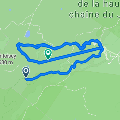
Overview
About this route
Lift served to start (Crozet) extremely technical ST at the top along the crest. Pick up time from Col de la Faucille to Vattay on the road, then up through the forest paths to La Dole. Hike-a-bike to La Dole summit, then fast, steep, rugged ST descent all the way to the Abbaye de Bonmont. Return along signposted route 50 to the Sauvergny road, then cut across towns from Sauvergny to Crozet to finish.
- -:--
- Duration
- 69.1 km
- Distance
- 1,050 m
- Ascent
- 1,702 m
- Descent
- ---
- Avg. speed
- ---
- Max. altitude
Continue with Bikemap
Use, edit, or download this cycling route
You would like to ride Crete du Jura or customize it for your own trip? Here is what you can do with this Bikemap route:
Free features
- Save this route as favorite or in collections
- Copy & plan your own version of this route
- Sync your route with Garmin or Wahoo
Premium features
Free trial for 3 days, or one-time payment. More about Bikemap Premium.
- Navigate this route on iOS & Android
- Export a GPX / KML file of this route
- Create your custom printout (try it for free)
- Download this route for offline navigation
Discover more Premium features.
Get Bikemap PremiumFrom our community
Other popular routes starting in Sergy
 Sergy Motz 1
- Distance
- 61.5 km
- Ascent
- 812 m
- Descent
- 848 m
- Location
- Sergy, Auvergne-Rhône-Alpes, France
 Big Bang Passport
- Distance
- 54.5 km
- Ascent
- 490 m
- Descent
- 490 m
- Location
- Sergy, Auvergne-Rhône-Alpes, France
 Crozet à Crozet
- Distance
- 10.3 km
- Ascent
- 994 m
- Descent
- 1,003 m
- Location
- Sergy, Auvergne-Rhône-Alpes, France
 Oxyrace Divonne parcours long
- Distance
- 109.4 km
- Ascent
- 1,772 m
- Descent
- 1,771 m
- Location
- Sergy, Auvergne-Rhône-Alpes, France
 Lelex - Lavans Vuillafans
- Distance
- 133.1 km
- Ascent
- 1,108 m
- Descent
- 1,388 m
- Location
- Sergy, Auvergne-Rhône-Alpes, France
 Sergy-Passrunde
- Distance
- 98.7 km
- Ascent
- 1,421 m
- Descent
- 1,421 m
- Location
- Sergy, Auvergne-Rhône-Alpes, France
 Route de Thoiry 92, Sergy naar Route d'Etoy 19, Lavigny
- Distance
- 67.1 km
- Ascent
- 1,258 m
- Descent
- 1,216 m
- Location
- Sergy, Auvergne-Rhône-Alpes, France
 Sergy Motz etape 1 - direct
- Distance
- 57.7 km
- Ascent
- 625 m
- Descent
- 654 m
- Location
- Sergy, Auvergne-Rhône-Alpes, France
Open it in the app