
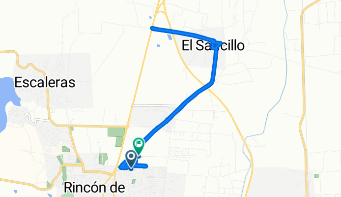
De Calle Valle del Real a 6MPQ+Q7
A cycling route starting in Rincón de Romos, Aguascalientes, Mexico.
Overview
About this route
- 1 h 5 min
- Duration
- 14.5 km
- Distance
- 121 m
- Ascent
- 105 m
- Descent
- 13.3 km/h
- Avg. speed
- 1,955 m
- Max. altitude
Route photos


Route quality
Waytypes & surfaces along the route
Waytypes
Road
12 km
(83 %)
Quiet road
2.2 km
(15 %)
Surfaces
Paved
12.8 km
(88 %)
Asphalt
11.8 km
(82 %)
Concrete
0.8 km
(6 %)
Continue with Bikemap
Use, edit, or download this cycling route
You would like to ride De Calle Valle del Real a 6MPQ+Q7 or customize it for your own trip? Here is what you can do with this Bikemap route:
Free features
- Save this route as favorite or in collections
- Copy & plan your own version of this route
- Sync your route with Garmin or Wahoo
Premium features
Free trial for 3 days, or one-time payment. More about Bikemap Premium.
- Navigate this route on iOS & Android
- Export a GPX / KML file of this route
- Create your custom printout (try it for free)
- Download this route for offline navigation
Discover more Premium features.
Get Bikemap PremiumFrom our community
Other popular routes starting in Rincón de Romos
 De Calle de la Concordia 106, Guadalupe a Calle de la Concordia 105, Guadalupe
- Distance
- 18.5 km
- Ascent
- 139 m
- Descent
- 137 m
- Location
- Rincón de Romos, Aguascalientes, Mexico
 De Calle de la Concordia 108, Guadalupe a Calle de la Concordia 108, Guadalupe
- Distance
- 16.8 km
- Ascent
- 94 m
- Descent
- 75 m
- Location
- Rincón de Romos, Aguascalientes, Mexico
 Calle Camino Real, El Saucillo a Calle 5 de Mayo 205A, El Saucillo
- Distance
- 29.9 km
- Ascent
- 525 m
- Descent
- 510 m
- Location
- Rincón de Romos, Aguascalientes, Mexico
 De Calle de la Concordia 112, Guadalupe a Calle de la Concordia 110, Guadalupe
- Distance
- 15 km
- Ascent
- 105 m
- Descent
- 107 m
- Location
- Rincón de Romos, Aguascalientes, Mexico
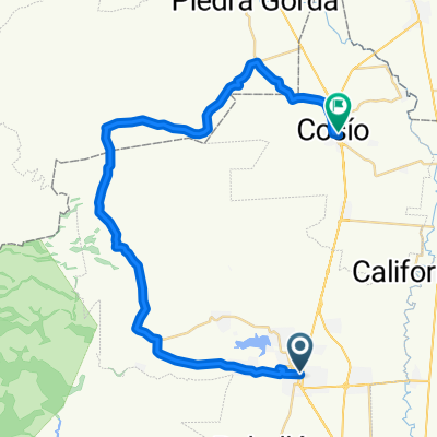 Rincon-Cosio
- Distance
- 47.3 km
- Ascent
- 576 m
- Descent
- 530 m
- Location
- Rincón de Romos, Aguascalientes, Mexico
 Paseo lento en Rincón de Romos
- Distance
- 22.8 km
- Ascent
- 270 m
- Descent
- 268 m
- Location
- Rincón de Romos, Aguascalientes, Mexico
 De Calle Ignacio Zaragoza 117, Rincón de Romos a Calle Ignacio Zaragoza 06, Rincón de Romos
- Distance
- 31.4 km
- Ascent
- 482 m
- Descent
- 482 m
- Location
- Rincón de Romos, Aguascalientes, Mexico
 De Aguascalientes 119 a Tlatoani 133, Rincón de Romos
- Distance
- 18.3 km
- Ascent
- 289 m
- Descent
- 369 m
- Location
- Rincón de Romos, Aguascalientes, Mexico
Open it in the app