
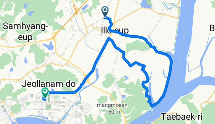
일로읍 705-1 ~ 삼향읍
A cycling route starting in Mokpo, Jeollanam-do, South Korea.
Overview
About this route
- 1 h 35 min
- Duration
- 21.7 km
- Distance
- 84 m
- Ascent
- 82 m
- Descent
- 13.7 km/h
- Avg. speed
- 33 m
- Max. altitude

Route photos


Route quality
Waytypes & surfaces along the route
Waytypes
Road
9.1 km
(42 %)
Cycleway
4.8 km
(22 %)
Surfaces
Paved
10.2 km
(47 %)
Asphalt
5.9 km
(27 %)
Concrete
3.7 km
(17 %)
Continue with Bikemap
Use, edit, or download this cycling route
You would like to ride 일로읍 705-1 ~ 삼향읍 or customize it for your own trip? Here is what you can do with this Bikemap route:
Free features
- Save this route as favorite or in collections
- Copy & plan your own version of this route
- Sync your route with Garmin or Wahoo
Premium features
Free trial for 3 days, or one-time payment. More about Bikemap Premium.
- Navigate this route on iOS & Android
- Export a GPX / KML file of this route
- Create your custom printout (try it for free)
- Download this route for offline navigation
Discover more Premium features.
Get Bikemap PremiumFrom our community
Other popular routes starting in Mokpo
![Ph0]에서 경로삼향읍](https://www.bikemap.net/media/temp/routes_gallery/60d48f6e-e669-46f6-9ac8-12b479cf7e01.jpg) Ph0]에서 경로삼향읍
Ph0]에서 경로삼향읍- Distance
- 37.1 km
- Ascent
- 75 m
- Descent
- 100 m
- Location
- Mokpo, Jeollanam-do, South Korea
 영암군 до 우산동, 광주광역시
- Distance
- 109.4 km
- Ascent
- 1,282 m
- Descent
- 1,269 m
- Location
- Mokpo, Jeollanam-do, South Korea
 목포 ~ 영산강 ~ 유성
- Distance
- 304.6 km
- Ascent
- 2,031 m
- Descent
- 1,998 m
- Location
- Mokpo, Jeollanam-do, South Korea
 Youngsan Jae RTC
- Distance
- 69 km
- Ascent
- 108 m
- Descent
- 108 m
- Location
- Mokpo, Jeollanam-do, South Korea
![삼향읍Ph0]으로 라우팅](https://media.bikemap.net/routes/17462175/gallery/thumbs/44108268-7455-4d94-b9a5-8c8eed7977b9.jpg.208x208_q80_crop.jpg) 삼향읍Ph0]으로 라우팅
삼향읍Ph0]으로 라우팅- Distance
- 25.2 km
- Ascent
- 49 m
- Descent
- 85 m
- Location
- Mokpo, Jeollanam-do, South Korea
![Ph0]에서 경로삼향읍](https://media.bikemap.net/routes/17406068/gallery/thumbs/7a848397-5332-4014-8f97-131d445b765c.jpg.208x208_q80_crop.jpg) Ph0]에서 경로삼향읍
Ph0]에서 경로삼향읍- Distance
- 9 km
- Ascent
- 39 m
- Descent
- 32 m
- Location
- Mokpo, Jeollanam-do, South Korea
![Ph0]에서 경로삼향읍 125-7](https://www.bikemap.net/media/temp/routes_gallery/ebafe84e-3488-4ee4-b599-0e16cba74036.jpg) Ph0]에서 경로삼향읍 125-7
Ph0]에서 경로삼향읍 125-7- Distance
- 31.5 km
- Ascent
- 64 m
- Descent
- 89 m
- Location
- Mokpo, Jeollanam-do, South Korea
- 일로읍 705-1 ~ 삼향읍
- Distance
- 21.7 km
- Ascent
- 84 m
- Descent
- 82 m
- Location
- Mokpo, Jeollanam-do, South Korea
Open it in the app