

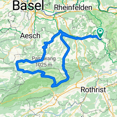
Oberer und Unterer Hauenstein mit Rothrist und Kölliken
A cycling route starting in Ormalingen, Basel-Landschaft, Switzerland.
Overview
About this route
Over the Oberen Hauenstein to Balsthal - Oensingen. Definitely make a detour to the pastry shop at the junction to Wolfwil (worth it). Continue towards Murgenthal - Rothenrist - Oftringen via Safenwil - Kölliken. Turnoff towards Schönenwerd/Aarau with a steep climb in the village. From Gretzenbach to Schönenwerd and via Winznau onto the Untere Hauenstein road. Continue over the pass into the Homburgertal valley and back home. Alternatively, from Schönenwerd to Aarau and via the Steffeleff or the Salhöhe into the Basel region.
- -:--
- Duration
- 114.3 km
- Distance
- 966 m
- Ascent
- 955 m
- Descent
- ---
- Avg. speed
- ---
- Max. altitude

Route quality
Waytypes & surfaces along the route
Waytypes
Quiet road
12.6 km
(11 %)
Road
9.1 km
(8 %)
Surfaces
Paved
83.5 km
(73 %)
Asphalt
82.3 km
(72 %)
Paved (undefined)
1.1 km
(1 %)
Undefined
30.9 km
(27 %)
Continue with Bikemap
Use, edit, or download this cycling route
You would like to ride Oberer und Unterer Hauenstein mit Rothrist und Kölliken or customize it for your own trip? Here is what you can do with this Bikemap route:
Free features
- Save this route as favorite or in collections
- Copy & plan your own version of this route
- Split it into stages to create a multi-day tour
- Sync your route with Garmin or Wahoo
Premium features
Free trial for 3 days, or one-time payment. More about Bikemap Premium.
- Navigate this route on iOS & Android
- Export a GPX / KML file of this route
- Create your custom printout (try it for free)
- Download this route for offline navigation
Discover more Premium features.
Get Bikemap PremiumFrom our community
Other popular routes starting in Ormalingen
 Tecknau Luzern
- Distance
- 85.8 km
- Ascent
- 934 m
- Descent
- 939 m
- Location
- Ormalingen, Basel-Landschaft, Switzerland
 Oberer und Unterer Hauenstein mit Rothrist und Kölliken
- Distance
- 114.3 km
- Ascent
- 966 m
- Descent
- 955 m
- Location
- Ormalingen, Basel-Landschaft, Switzerland
 Hauenstein - Teufelsschlucht - Longbridge
- Distance
- 72.3 km
- Ascent
- 776 m
- Descent
- 783 m
- Location
- Ormalingen, Basel-Landschaft, Switzerland
 1. August-Tour Mandacherhöhe
- Distance
- 87.8 km
- Ascent
- 1,055 m
- Descent
- 1,047 m
- Location
- Ormalingen, Basel-Landschaft, Switzerland
 Schupfart - Frick - Kaisteerberg - Laufenburg - Mumpf - Kaiseraugst - Arisdorf - Windentalhöhe - Sissacher Flue - Rothenfluh
- Distance
- 86.7 km
- Ascent
- 731 m
- Descent
- 731 m
- Location
- Ormalingen, Basel-Landschaft, Switzerland
 Rothenfluh - Diegten - Langenbruck - Mümliswil - Passwang - Büsserach - Fehren - Nunningen - Reigoldswil - Oberdorf - Hölstein - Diegten - Sissach - Rothenfluh
- Distance
- 102 km
- Ascent
- 1,490 m
- Descent
- 1,490 m
- Location
- Ormalingen, Basel-Landschaft, Switzerland
 Albtal - St. Blasien - Wehratal
- Distance
- 121.2 km
- Ascent
- 1,196 m
- Descent
- 1,190 m
- Location
- Ormalingen, Basel-Landschaft, Switzerland
 Passwang - Unt. Hauenstein
- Distance
- 113.1 km
- Ascent
- 1,210 m
- Descent
- 1,204 m
- Location
- Ormalingen, Basel-Landschaft, Switzerland
Open it in the app