

Sobín
A cycling route starting in Měcholupy, Ústecký kraj, Czechia.
Overview
About this route
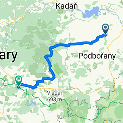
From Kněževi along the route of Kolešovky to Lišany, then through Louštín and around Lánská Obora to Sobín Castle. Then along the educational trail to Novostrašecko and finally around the ponds to Řevničova and Krupá.
- -:--
- Duration
- 72.8 km
- Distance
- 659 m
- Ascent
- 631 m
- Descent
- ---
- Avg. speed
- 536 m
- Max. altitude
Route quality
Waytypes & surfaces along the route
Waytypes
Track
32.8 km
(45 %)
Quiet road
13.1 km
(18 %)
Surfaces
Paved
8.7 km
(12 %)
Unpaved
32.8 km
(45 %)
Gravel
12.4 km
(17 %)
Ground
12.4 km
(17 %)
Continue with Bikemap
Use, edit, or download this cycling route
You would like to ride Sobín or customize it for your own trip? Here is what you can do with this Bikemap route:
Free features
- Save this route as favorite or in collections
- Copy & plan your own version of this route
- Sync your route with Garmin or Wahoo
Premium features
Free trial for 3 days, or one-time payment. More about Bikemap Premium.
- Navigate this route on iOS & Android
- Export a GPX / KML file of this route
- Create your custom printout (try it for free)
- Download this route for offline navigation
Discover more Premium features.
Get Bikemap PremiumFrom our community
Other popular routes starting in Měcholupy
 Day 27
- Distance
- 54.8 km
- Ascent
- 922 m
- Descent
- 665 m
- Location
- Měcholupy, Ústecký kraj, Czechia
 MZ Louny 1. Etapa
- Distance
- 9.4 km
- Ascent
- 165 m
- Descent
- 167 m
- Location
- Měcholupy, Ústecký kraj, Czechia
 Prales Klíčín CLONED FROM ROUTE 1440346
- Distance
- 2.6 km
- Ascent
- 87 m
- Descent
- 87 m
- Location
- Měcholupy, Ústecký kraj, Czechia
 Tam-A
Tam-A- Distance
- 168.9 km
- Ascent
- 2,563 m
- Descent
- 2,616 m
- Location
- Měcholupy, Ústecký kraj, Czechia
 Silnice 22721, Libořice to Hornická 2963, Chomutov
- Distance
- 35.8 km
- Ascent
- 333 m
- Descent
- 243 m
- Location
- Měcholupy, Ústecký kraj, Czechia
 měcholupy
- Distance
- 48.9 km
- Ascent
- 571 m
- Descent
- 535 m
- Location
- Měcholupy, Ústecký kraj, Czechia
 měcho - třeskonice 30 km
- Distance
- 29.1 km
- Ascent
- 356 m
- Descent
- 352 m
- Location
- Měcholupy, Ústecký kraj, Czechia
 Tuchořické okruhy a rozjezd
- Distance
- 84.3 km
- Ascent
- 1,278 m
- Descent
- 1,278 m
- Location
- Měcholupy, Ústecký kraj, Czechia
Open it in the app