

2012_08 Provence
Gréoux-les-Bains _Bonnieux
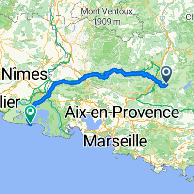
A cycling route starting in Gréoux-les-Bains, Provence-Alpes-Côte d'Azur Region, France.
Overview
About this route
August 9, 2012
- -:--
- Duration
- 65.2 km
- Distance
- 534 m
- Ascent
- 466 m
- Descent
- ---
- Avg. speed
- ---
- Max. altitude

Part of
2012_08 Provence
7 stages
Route quality
Waytypes & surfaces along the route
Waytypes
Road
16.3 km
(25 %)
Quiet road
16.3 km
(25 %)
Surfaces
Paved
31.9 km
(49 %)
Unpaved
0.7 km
(1 %)
Asphalt
31.9 km
(49 %)
Gravel
0.7 km
(1 %)
Undefined
32.6 km
(50 %)
Route highlights
Points of interest along the route
Point of interest after 0.4 km
Camping Le Lac
Point of interest after 0.4 km
camping la grangeonne
Point of interest after 0.4 km
Camping du Soleil
Continue with Bikemap
Use, edit, or download this cycling route
You would like to ride Gréoux-les-Bains _Bonnieux or customize it for your own trip? Here is what you can do with this Bikemap route:
Free features
- Save this route as favorite or in collections
- Copy & plan your own version of this route
- Sync your route with Garmin or Wahoo
Premium features
Free trial for 3 days, or one-time payment. More about Bikemap Premium.
- Navigate this route on iOS & Android
- Export a GPX / KML file of this route
- Create your custom printout (try it for free)
- Download this route for offline navigation
Discover more Premium features.
Get Bikemap PremiumFrom our community
Other popular routes starting in Gréoux-les-Bains
 Gréoux-les-Bains _Bonnieux
- Distance
- 65.2 km
- Ascent
- 534 m
- Descent
- 466 m
- Location
- Gréoux-les-Bains, Provence-Alpes-Côte d'Azur Region, France
 #9 Gréoux les Bains - St. Tropez
- Distance
- 145.2 km
- Ascent
- 3,655 m
- Descent
- 3,978 m
- Location
- Gréoux-les-Bains, Provence-Alpes-Côte d'Azur Region, France
 Mittwoch
- Distance
- 117.4 km
- Ascent
- 1,377 m
- Descent
- 1,363 m
- Location
- Gréoux-les-Bains, Provence-Alpes-Côte d'Azur Region, France
 Gréoux-Defend-AR
- Distance
- 13.8 km
- Ascent
- 432 m
- Descent
- 441 m
- Location
- Gréoux-les-Bains, Provence-Alpes-Côte d'Azur Region, France
 Dalle Alpi al Mont Ventoux: Giorno 4: Route 1. Gréoux-les-Bains - Sant Martin De Crau
- Distance
- 121.4 km
- Ascent
- 651 m
- Descent
- 997 m
- Location
- Gréoux-les-Bains, Provence-Alpes-Côte d'Azur Region, France
 Luberon-Camargue
- Distance
- 180.2 km
- Ascent
- 717 m
- Descent
- 1,071 m
- Location
- Gréoux-les-Bains, Provence-Alpes-Côte d'Azur Region, France
 J1 Gréoux-Ste-Croix
- Distance
- 51.6 km
- Ascent
- 619 m
- Descent
- 475 m
- Location
- Gréoux-les-Bains, Provence-Alpes-Côte d'Azur Region, France
 Boucle vélo Petit Plateau
- Distance
- 35.7 km
- Ascent
- 371 m
- Descent
- 371 m
- Location
- Gréoux-les-Bains, Provence-Alpes-Côte d'Azur Region, France
Open it in the app