
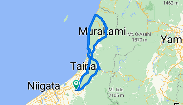
新発田→天蓋高原→夕陽の海岸コース
A cycling route starting in Shibata, Niigata, Japan.
Overview
About this route
A course that offers views of the Tengai Plateau and the Sea of Japan. National Route 7 has heavy traffic, so be careful. Do not ride on the sidewalks. This is regulated by traffic laws, but there are foreign objects that can cause punctures, as well as curbs and bumps on the roadside. Especially after sunset, the glaring headlights of oncoming vehicles make it hard to see the ground and it is dangerous.
- -:--
- Duration
- 165.2 km
- Distance
- 748 m
- Ascent
- 748 m
- Descent
- ---
- Avg. speed
- ---
- Max. altitude
Continue with Bikemap
Use, edit, or download this cycling route
You would like to ride 新発田→天蓋高原→夕陽の海岸コース or customize it for your own trip? Here is what you can do with this Bikemap route:
Free features
- Save this route as favorite or in collections
- Copy & plan your own version of this route
- Split it into stages to create a multi-day tour
- Sync your route with Garmin or Wahoo
Premium features
Free trial for 3 days, or one-time payment. More about Bikemap Premium.
- Navigate this route on iOS & Android
- Export a GPX / KML file of this route
- Create your custom printout (try it for free)
- Download this route for offline navigation
Discover more Premium features.
Get Bikemap PremiumFrom our community
Other popular routes starting in Shibata
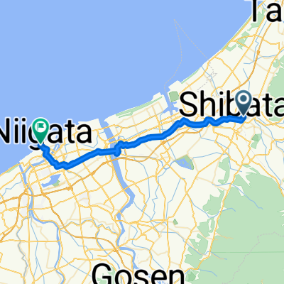 Shibata - Niigata
- Distance
- 35 km
- Ascent
- 75 m
- Descent
- 73 m
- Location
- Shibata, Niigata, Japan
 甲2211, Shibata to 1-chōme 1, Shibata
- Distance
- 2.8 km
- Ascent
- 3 m
- Descent
- 4 m
- Location
- Shibata, Niigata, Japan
 Home to Nitori
- Distance
- 3.5 km
- Ascent
- 5 m
- Descent
- 13 m
- Location
- Shibata, Niigata, Japan
 聖籠町 to 2丁目 3, 新潟市
- Distance
- 18.8 km
- Ascent
- 57 m
- Descent
- 57 m
- Location
- Shibata, Niigata, Japan
 1-chōme 1, Shibata to 1-chōme 1, Shibata
- Distance
- 5.8 km
- Ascent
- 20 m
- Descent
- 18 m
- Location
- Shibata, Niigata, Japan
 新発田→樽口峠
- Distance
- 65 km
- Ascent
- 832 m
- Descent
- 350 m
- Location
- Shibata, Niigata, Japan
 新発田→赤谷治水ダム
- Distance
- 48.4 km
- Ascent
- 371 m
- Descent
- 371 m
- Location
- Shibata, Niigata, Japan
 新発田→天蓋高原→夕陽の海岸コース
- Distance
- 165.2 km
- Ascent
- 748 m
- Descent
- 748 m
- Location
- Shibata, Niigata, Japan
Open it in the app