
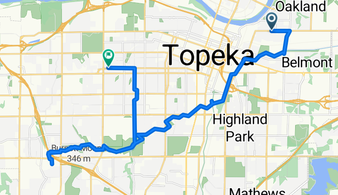
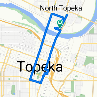
Northeast Seward Avenue to Southwest Munson Avenue
A cycling route starting in Topeka, Kansas, United States.
Overview
About this route
- 1 h 37 min
- Duration
- 24.7 km
- Distance
- 99 m
- Ascent
- 50 m
- Descent
- 15.3 km/h
- Avg. speed
- 307 m
- Max. altitude
Route photos


Route quality
Waytypes & surfaces along the route
Waytypes
Cycleway
18 km
(73 %)
Quiet road
3.5 km
(14 %)
Surfaces
Paved
15.3 km
(62 %)
Paved (undefined)
10.8 km
(44 %)
Concrete
4.4 km
(18 %)
Undefined
9.4 km
(38 %)
Continue with Bikemap
Use, edit, or download this cycling route
You would like to ride Northeast Seward Avenue to Southwest Munson Avenue or customize it for your own trip? Here is what you can do with this Bikemap route:
Free features
- Save this route as favorite or in collections
- Copy & plan your own version of this route
- Sync your route with Garmin or Wahoo
Premium features
Free trial for 3 days, or one-time payment. More about Bikemap Premium.
- Navigate this route on iOS & Android
- Export a GPX / KML file of this route
- Create your custom printout (try it for free)
- Download this route for offline navigation
Discover more Premium features.
Get Bikemap PremiumFrom our community
Other popular routes starting in Topeka
- Northeast Seward Avenue to Southwest Munson Avenue
- Distance
- 24.7 km
- Ascent
- 99 m
- Descent
- 50 m
- Location
- Topeka, Kansas, United States
 College Hill to Lake Shawnee 35 miler
- Distance
- 56.1 km
- Ascent
- 105 m
- Descent
- 104 m
- Location
- Topeka, Kansas, United States
 USA CC 27
- Distance
- 141.8 km
- Ascent
- 390 m
- Descent
- 388 m
- Location
- Topeka, Kansas, United States
 Sunga-Landon 15 mile
- Distance
- 24.5 km
- Ascent
- 53 m
- Descent
- 53 m
- Location
- Topeka, Kansas, United States
 Yacht Ct, Topeka to 3140 SE 21st St, Topeka
- Distance
- 25.2 km
- Ascent
- 190 m
- Descent
- 218 m
- Location
- Topeka, Kansas, United States
 North Kansas Avenue 600, Topeka to North Kansas Avenue 600, Topeka
- Distance
- 10.2 km
- Ascent
- 84 m
- Descent
- 92 m
- Location
- Topeka, Kansas, United States
 Bonnie's donut run
- Distance
- 1,332.8 km
- Ascent
- 5,370 m
- Descent
- 5,652 m
- Location
- Topeka, Kansas, United States
 Southwest Lincoln Street 904, Topeka to Southeast Axton Street 501, Unincorporated
- Distance
- 13.7 km
- Ascent
- 61 m
- Descent
- 33 m
- Location
- Topeka, Kansas, United States
Open it in the app