

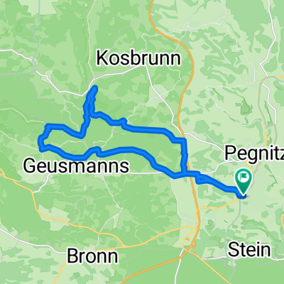
Runde nach Königsstein
A cycling route starting in Pegnitz, Bavaria, Germany.
Overview
About this route
Partly district roads but also a short stretch of federal highway, then peacefully across open spaces and through tranquil wooded areas.
- -:--
- Duration
- 56.6 km
- Distance
- 521 m
- Ascent
- 518 m
- Descent
- ---
- Avg. speed
- ---
- Max. altitude

Route quality
Waytypes & surfaces along the route
Waytypes
Road
14.7 km
(26 %)
Quiet road
10.8 km
(19 %)
Surfaces
Paved
43.6 km
(77 %)
Unpaved
1.1 km
(2 %)
Asphalt
43.6 km
(77 %)
Ground
1.1 km
(2 %)
Undefined
11.9 km
(21 %)
Continue with Bikemap
Use, edit, or download this cycling route
You would like to ride Runde nach Königsstein or customize it for your own trip? Here is what you can do with this Bikemap route:
Free features
- Save this route as favorite or in collections
- Copy & plan your own version of this route
- Sync your route with Garmin or Wahoo
Premium features
Free trial for 3 days, or one-time payment. More about Bikemap Premium.
- Navigate this route on iOS & Android
- Export a GPX / KML file of this route
- Create your custom printout (try it for free)
- Download this route for offline navigation
Discover more Premium features.
Get Bikemap PremiumFrom our community
Other popular routes starting in Pegnitz
 Pegnitz-Weiglathal-Leups-Pegnitz
- Distance
- 55.8 km
- Ascent
- 788 m
- Descent
- 786 m
- Location
- Pegnitz, Bavaria, Germany
 Pegnitz - Kleiner Kulm - Pegnitz
- Distance
- 14.1 km
- Ascent
- 396 m
- Descent
- 394 m
- Location
- Pegnitz, Bavaria, Germany
 Bronn-Michelfeld
- Distance
- 10.7 km
- Ascent
- 162 m
- Descent
- 176 m
- Location
- Pegnitz, Bavaria, Germany
 Pegnitz - Bayreuth
- Distance
- 90.7 km
- Ascent
- 570 m
- Descent
- 652 m
- Location
- Pegnitz, Bavaria, Germany
 Veldensteiner Forst - Burg Hartenstein
- Distance
- 48.7 km
- Ascent
- 590 m
- Descent
- 587 m
- Location
- Pegnitz, Bavaria, Germany
 Schiem-a-no.de: Tour1/Pegnitz-Pottenstein
- Distance
- 35.1 km
- Ascent
- 647 m
- Descent
- 647 m
- Location
- Pegnitz, Bavaria, Germany
 Rundweg Pegnitz Elbersberg Hollenberg
- Distance
- 19.2 km
- Ascent
- 332 m
- Descent
- 332 m
- Location
- Pegnitz, Bavaria, Germany
 Von Pegnitz durch den Veldensteiner Forst
- Distance
- 83.7 km
- Ascent
- 624 m
- Descent
- 575 m
- Location
- Pegnitz, Bavaria, Germany
Open it in the app