

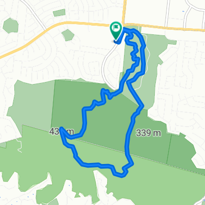
Hotel Waltk
A cycling route starting in Rowland Heights, California, United States of America.
Overview
About this route
- -:--
- Duration
- 8.3 km
- Distance
- 320 m
- Ascent
- 320 m
- Descent
- ---
- Avg. speed
- ---
- Max. altitude

Continue with Bikemap
Use, edit, or download this cycling route
You would like to ride Hotel Waltk or customize it for your own trip? Here is what you can do with this Bikemap route:
Free features
- Save this route as favorite or in collections
- Copy & plan your own version of this route
- Sync your route with Garmin or Wahoo
Premium features
Free trial for 3 days, or one-time payment. More about Bikemap Premium.
- Navigate this route on iOS & Android
- Export a GPX / KML file of this route
- Create your custom printout (try it for free)
- Download this route for offline navigation
Discover more Premium features.
Get Bikemap PremiumFrom our community
Other popular routes starting in Rowland Heights
 1749 Batson Ave, Rowland Heights to 18150 Pathfinder Rd, Rowland Heights
- Distance
- 5.5 km
- Ascent
- 84 m
- Descent
- 22 m
- Location
- Rowland Heights, California, United States of America
 Hotel Waltk
- Distance
- 8.3 km
- Ascent
- 320 m
- Descent
- 320 m
- Location
- Rowland Heights, California, United States of America
 Powder Canyon Motorway, Rowland Heights to Powder Canyon Motorway, Rowland Heights
- Distance
- 6.9 km
- Ascent
- 299 m
- Descent
- 299 m
- Location
- Rowland Heights, California, United States of America
 Powder Canyon Motorway, Rowland Heights to Powder Canyon Motorway, Rowland Heights
- Distance
- 6.5 km
- Ascent
- 267 m
- Descent
- 267 m
- Location
- Rowland Heights, California, United States of America
 1675 Hanover Rd, Industry to 13578–13598 Don Julian Rd, La Puente
- Distance
- 10.6 km
- Ascent
- 19 m
- Descent
- 65 m
- Location
- Rowland Heights, California, United States of America
 17250 E Colima Rd, Rowland Heights to 17250 E Colima Rd, Rowland Heights
- Distance
- 0.5 km
- Ascent
- 10 m
- Descent
- 0 m
- Location
- Rowland Heights, California, United States of America
 park walk
- Distance
- 2.1 km
- Ascent
- 76 m
- Descent
- 75 m
- Location
- Rowland Heights, California, United States of America
 Rowland Heights to Rowland Heights
- Distance
- 32.1 km
- Ascent
- 805 m
- Descent
- 809 m
- Location
- Rowland Heights, California, United States of America
Open it in the app