
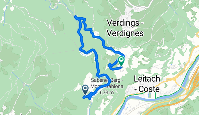
Muttner, Chiusa až Via Pradello, Chiusa
A cycling route starting in Klausen, Trentino-Alto Adige, Italy.
Overview
About this route
- 25 min
- Duration
- 4.8 km
- Distance
- 233 m
- Ascent
- 173 m
- Descent
- 11.5 km/h
- Avg. speed
- 800 m
- Max. altitude

Route quality
Waytypes & surfaces along the route
Waytypes
Quiet road
3.7 km
(77 %)
Access road
1.1 km
(23 %)
Surfaces
Paved
4.7 km
(98 %)
Asphalt
4.7 km
(98 %)
Undefined
0.1 km
(2 %)
Continue with Bikemap
Use, edit, or download this cycling route
You would like to ride Muttner, Chiusa až Via Pradello, Chiusa or customize it for your own trip? Here is what you can do with this Bikemap route:
Free features
- Save this route as favorite or in collections
- Copy & plan your own version of this route
- Sync your route with Garmin or Wahoo
Premium features
Free trial for 3 days, or one-time payment. More about Bikemap Premium.
- Navigate this route on iOS & Android
- Export a GPX / KML file of this route
- Create your custom printout (try it for free)
- Download this route for offline navigation
Discover more Premium features.
Get Bikemap PremiumFrom our community
Other popular routes starting in Klausen
 Klausen - Plose (Seilbahn) - Villnösstal2
- Distance
- 53.4 km
- Ascent
- 1,986 m
- Descent
- 1,984 m
- Location
- Klausen, Trentino-Alto Adige, Italy
 Dolomitenrunde No2 2011
- Distance
- 139.3 km
- Ascent
- 3,314 m
- Descent
- 3,307 m
- Location
- Klausen, Trentino-Alto Adige, Italy
 2021 #1 Chuisa-Toblach
- Distance
- 86.9 km
- Ascent
- 966 m
- Descent
- 286 m
- Location
- Klausen, Trentino-Alto Adige, Italy
 Klausen-Sarntal-PenserJoch-Runde
- Distance
- 132.4 km
- Ascent
- 1,919 m
- Descent
- 1,919 m
- Location
- Klausen, Trentino-Alto Adige, Italy
 Winh.-Gardasee-2.Tag-2
- Distance
- 166 km
- Ascent
- 112 m
- Descent
- 548 m
- Location
- Klausen, Trentino-Alto Adige, Italy
 Klausen (IT) - Stilfser Joch - Santa Maria Val Müstair / Etappe 3
- Distance
- 149.8 km
- Ascent
- 2,470 m
- Descent
- 1,638 m
- Location
- Klausen, Trentino-Alto Adige, Italy
 Giro Sarentino
- Distance
- 133.2 km
- Ascent
- 2,317 m
- Descent
- 2,319 m
- Location
- Klausen, Trentino-Alto Adige, Italy
 Südl. Gardasee Radreise
- Distance
- 333.1 km
- Ascent
- 7,820 m
- Descent
- 7,481 m
- Location
- Klausen, Trentino-Alto Adige, Italy
Open it in the app