
len tak
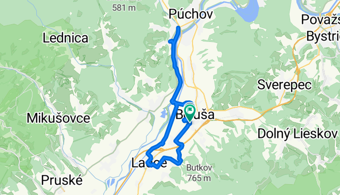
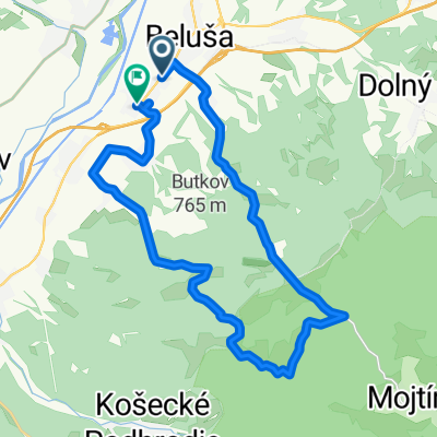
A cycling route starting in Púchov, Nitra Region, Slovakia.
Overview
About this route
- 3 h 31 min
- Duration
- 26.4 km
- Distance
- 132 m
- Ascent
- 154 m
- Descent
- 7.5 km/h
- Avg. speed
- 300 m
- Max. altitude
Route photos


Route quality
Waytypes & surfaces along the route
Waytypes
Cycleway
12.9 km
(49 %)
Road
5.8 km
(22 %)
Surfaces
Paved
21.9 km
(83 %)
Unpaved
1.1 km
(4 %)
Asphalt
21.9 km
(83 %)
Gravel
0.8 km
(3 %)
Continue with Bikemap
Use, edit, or download this cycling route
You would like to ride len tak or customize it for your own trip? Here is what you can do with this Bikemap route:
Free features
- Save this route as favorite or in collections
- Copy & plan your own version of this route
- Sync your route with Garmin or Wahoo
Premium features
Free trial for 3 days, or one-time payment. More about Bikemap Premium.
- Navigate this route on iOS & Android
- Export a GPX / KML file of this route
- Create your custom printout (try it for free)
- Download this route for offline navigation
Discover more Premium features.
Get Bikemap PremiumFrom our community
Other popular routes starting in Púchov
 Námestie Slobody 560 do Námestie Slobody 26
- Distance
- 32.9 km
- Ascent
- 534 m
- Descent
- 477 m
- Location
- Púchov, Nitra Region, Slovakia
 Lysá pod Makytou do Lysá pod Makytou
- Distance
- 15.4 km
- Ascent
- 308 m
- Descent
- 365 m
- Location
- Púchov, Nitra Region, Slovakia
 MTB Puchov-Bytca (takmer)
- Distance
- 32.6 km
- Ascent
- 629 m
- Descent
- 486 m
- Location
- Púchov, Nitra Region, Slovakia
- len tak
- Distance
- 26.4 km
- Ascent
- 132 m
- Descent
- 154 m
- Location
- Púchov, Nitra Region, Slovakia
 Belušský kanál - malý okruh
- Distance
- 10.9 km
- Ascent
- 14 m
- Descent
- 14 m
- Location
- Púchov, Nitra Region, Slovakia
 Slatiny, Mraznica, Ladce
- Distance
- 24.6 km
- Ascent
- 457 m
- Descent
- 464 m
- Location
- Púchov, Nitra Region, Slovakia
 Púchov- Beluša- Visolaje- Tŕstie- Pružina
- Distance
- 24 km
- Ascent
- 155 m
- Descent
- 39 m
- Location
- Púchov, Nitra Region, Slovakia
 Visolaje - Kanada
- Distance
- 35.7 km
- Ascent
- 808 m
- Descent
- 808 m
- Location
- Púchov, Nitra Region, Slovakia
Open it in the app