

1st Fun Biker Taiwan Cycling Activity
A cycling route starting in Zhubei, Taiwan, Taiwan.
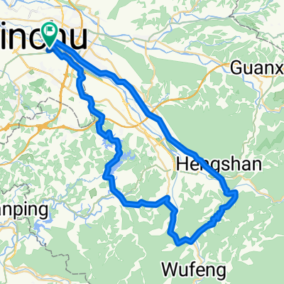
Overview
About this route
Total 7 Days (From 5/10 to 5/16'09)
Attendees:
Mike, Eric, Sam, Kenny, Vincent, Moore, Jack, Gary, John, Tim, Kevin, Daniel
Christiana (Card support)
Start: 新竹
Stop Point: 鹿港, 台南市, 楓港, 鹿野, 花蓮, 金山 --> 回新竹
- -:--
- Duration
- 988.8 km
- Distance
- 1,413 m
- Ascent
- 1,419 m
- Descent
- ---
- Avg. speed
- ---
- Max. altitude
Route highlights
Points of interest along the route
Point of interest after 0 km
Point of interest after 0.6 km
End Point
Accommodation after 117.1 km
1'st Stop.
Accommodation after 254.4 km
2nd Stop Point
Accommodation after 369.8 km
3rd Stop Point
Accommodation after 489.8 km
4th Stop Point
Accommodation after 633 km
5th Stop Point
Point of interest after 746.5 km
6th day Start Point
Accommodation after 866.6 km
6th Day Stop Point
Continue with Bikemap
Use, edit, or download this cycling route
You would like to ride 1st Fun Biker Taiwan Cycling Activity or customize it for your own trip? Here is what you can do with this Bikemap route:
Free features
- Save this route as favorite or in collections
- Copy & plan your own version of this route
- Split it into stages to create a multi-day tour
- Sync your route with Garmin or Wahoo
Premium features
Free trial for 3 days, or one-time payment. More about Bikemap Premium.
- Navigate this route on iOS & Android
- Export a GPX / KML file of this route
- Create your custom printout (try it for free)
- Download this route for offline navigation
Discover more Premium features.
Get Bikemap PremiumFrom our community
Other popular routes starting in Zhubei
 2009/12/19 大山背/北埔/寶一二水庫
- Distance
- 64.2 km
- Ascent
- 1,244 m
- Descent
- 1,179 m
- Location
- Zhubei, Taiwan, Taiwan
 中等路線 竹北市夜騎路線
- Distance
- 23.2 km
- Ascent
- 187 m
- Descent
- 183 m
- Location
- Zhubei, Taiwan, Taiwan
 2009 Lander單車環島行
- Distance
- 1,065.2 km
- Ascent
- 1,602 m
- Descent
- 1,604 m
- Location
- Zhubei, Taiwan, Taiwan
 宇老大滿貫(120,台7,118,台3)
- Distance
- 107.1 km
- Ascent
- 1,714 m
- Descent
- 1,714 m
- Location
- Zhubei, Taiwan, Taiwan
 好久沒有騎這麼遠了!
- Distance
- 37.6 km
- Ascent
- 219 m
- Descent
- 239 m
- Location
- Zhubei, Taiwan, Taiwan
 yangmei tea ride
- Distance
- 22.8 km
- Ascent
- 669 m
- Descent
- 639 m
- Location
- Zhubei, Taiwan, Taiwan
 自強北路190號, 新竹縣 to 成功八路339號–385號, 竹北市
- Distance
- 42.3 km
- Ascent
- 474 m
- Descent
- 473 m
- Location
- Zhubei, Taiwan, Taiwan
 FormFactor Cycling Taiwan Plan
- Distance
- 930.1 km
- Ascent
- 1,919 m
- Descent
- 1,918 m
- Location
- Zhubei, Taiwan, Taiwan
Open it in the app