
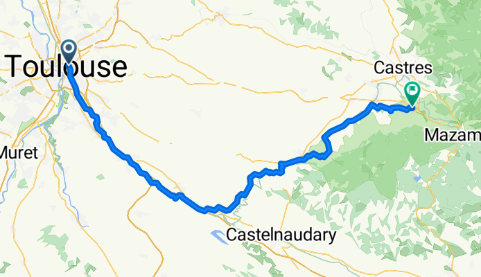
Toulouse - Labastide-Rouairoux
A cycling route starting in Toulouse, Occitanie, France.
Overview
About this route
- 6 h 53 min
- Duration
- 106.1 km
- Distance
- 753 m
- Ascent
- 714 m
- Descent
- 15.4 km/h
- Avg. speed
- 274 m
- Max. altitude

Route quality
Waytypes & surfaces along the route
Waytypes
Quiet road
35 km
(33 %)
Cycleway
25.5 km
(24 %)
Surfaces
Paved
54.1 km
(51 %)
Unpaved
22.3 km
(21 %)
Asphalt
54.1 km
(51 %)
Gravel
10.6 km
(10 %)
Continue with Bikemap
Use, edit, or download this cycling route
You would like to ride Toulouse - Labastide-Rouairoux or customize it for your own trip? Here is what you can do with this Bikemap route:
Free features
- Save this route as favorite or in collections
- Copy & plan your own version of this route
- Split it into stages to create a multi-day tour
- Sync your route with Garmin or Wahoo
Premium features
Free trial for 3 days, or one-time payment. More about Bikemap Premium.
- Navigate this route on iOS & Android
- Export a GPX / KML file of this route
- Create your custom printout (try it for free)
- Download this route for offline navigation
Discover more Premium features.
Get Bikemap PremiumFrom our community
Other popular routes starting in Toulouse
 Les coteaux du lauraguais
- Distance
- 106.3 km
- Ascent
- 610 m
- Descent
- 610 m
- Location
- Toulouse, Occitanie, France
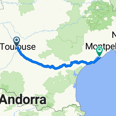
 Canal du midi
- Distance
- 242.7 km
- Ascent
- 116 m
- Descent
- 241 m
- Location
- Toulouse, Occitanie, France
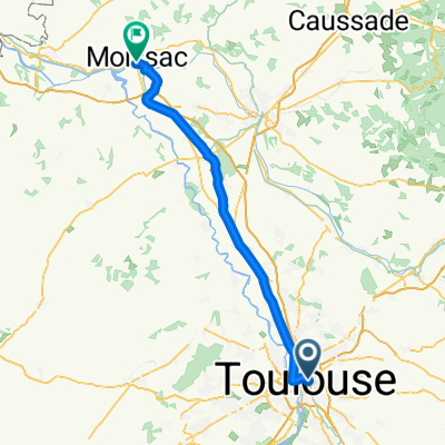 Rue de l'Orient, Toulouse to Rue du Pont, Moissac
- Distance
- 71.6 km
- Ascent
- 60 m
- Descent
- 140 m
- Location
- Toulouse, Occitanie, France
 Rundtour Albigeois, 1. Etappe
- Distance
- 47.7 km
- Ascent
- 282 m
- Descent
- 218 m
- Location
- Toulouse, Occitanie, France
 1. France
- Distance
- 873.4 km
- Ascent
- 5,508 m
- Descent
- 5,648 m
- Location
- Toulouse, Occitanie, France
 Toulouse - Agrunalet
- Distance
- 330 km
- Ascent
- 2,613 m
- Descent
- 2,419 m
- Location
- Toulouse, Occitanie, France
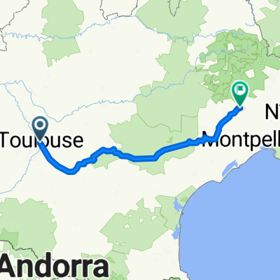
 Canal du midi
- Distance
- 242.7 km
- Ascent
- 108 m
- Descent
- 237 m
- Location
- Toulouse, Occitanie, France
 From Toulouse to Saint-Bauzille-de-Putois
- Distance
- 280.2 km
- Ascent
- 3,876 m
- Descent
- 3,903 m
- Location
- Toulouse, Occitanie, France
Open it in the app