

Marcha Ferrolterra 2012
A cycling route starting in Ferrol, Galicia, Spain.
Overview
About this route
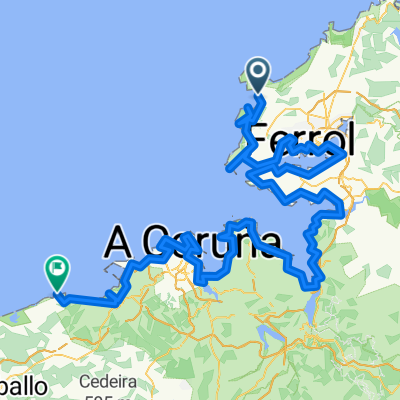
La Malata, O Val, Meiras, Valdoviño, Alto de Valdoviño, Pantin, Alto de Baleo, Vilarrube, Campo da Cruz, Cedeira, Pardiñeira (inicio 1º tramo libre), Mdor dos Carrís, Garita Herbeira, Cariño (Avituallamiento), Ponte Mera, Felgosas, Cerdico (Estacion Feve), Labacencos, Balocos, Moeche, San Sadurniño, Pedroso (inicio 2º tramo libre), Sedes, A Carreira, Concha, Mandia, Serantes, La Malata.
- -:--
- Duration
- 125.5 km
- Distance
- 1,658 m
- Ascent
- 1,657 m
- Descent
- ---
- Avg. speed
- ---
- Max. altitude

Route quality
Waytypes & surfaces along the route
Waytypes
Busy road
56.2 km
(45 %)
Road
46.7 km
(37 %)
Surfaces
Paved
37.4 km
(30 %)
Unpaved
0.2 km
(<1 %)
Asphalt
37.4 km
(30 %)
Unpaved (undefined)
0.2 km
(<1 %)
Undefined
87.8 km
(70 %)
Route highlights
Points of interest along the route
Point of interest after 44.3 km
Mirador dos Carrís
Point of interest after 50.3 km
Garita da Herbeira
Point of interest after 59.3 km
Avituallamiento
Point of interest after 105.6 km
Pereiruga
Continue with Bikemap
Use, edit, or download this cycling route
You would like to ride Marcha Ferrolterra 2012 or customize it for your own trip? Here is what you can do with this Bikemap route:
Free features
- Save this route as favorite or in collections
- Copy & plan your own version of this route
- Split it into stages to create a multi-day tour
- Sync your route with Garmin or Wahoo
Premium features
Free trial for 3 days, or one-time payment. More about Bikemap Premium.
- Navigate this route on iOS & Android
- Export a GPX / KML file of this route
- Create your custom printout (try it for free)
- Download this route for offline navigation
Discover more Premium features.
Get Bikemap PremiumFrom our community
Other popular routes starting in Ferrol
 ferrol-garita de herveira-ortigueira-as pontes
- Distance
- 147.2 km
- Ascent
- 1,676 m
- Descent
- 1,719 m
- Location
- Ferrol, Galicia, Spain
 XIX Marcha Ferrolterra 2016
- Distance
- 126.7 km
- Ascent
- 1,507 m
- Descent
- 1,507 m
- Location
- Ferrol, Galicia, Spain
 Castillo San Felipe
- Distance
- 8.2 km
- Ascent
- 193 m
- Descent
- 254 m
- Location
- Ferrol, Galicia, Spain
 Ferrol- Santiago- Ferrol
- Distance
- 221.3 km
- Ascent
- 1,546 m
- Descent
- 1,543 m
- Location
- Ferrol, Galicia, Spain
 Ruta Campus Serantes- Campus de Esteiro
- Distance
- 5.3 km
- Ascent
- 53 m
- Descent
- 45 m
- Location
- Ferrol, Galicia, Spain
 Ruta de los faros III
- Distance
- 183.9 km
- Ascent
- 762 m
- Descent
- 764 m
- Location
- Ferrol, Galicia, Spain
 Subida a Chamorro
- Distance
- 1 km
- Ascent
- 122 m
- Descent
- 23 m
- Location
- Ferrol, Galicia, Spain
 Ruta por las Rias de Ferrol y Ares: Ferrol-Mugardos por la costa, Castelo da Palma y playa de Chanteiro
- Distance
- 44.8 km
- Ascent
- 855 m
- Descent
- 827 m
- Location
- Ferrol, Galicia, Spain
Open it in the app