
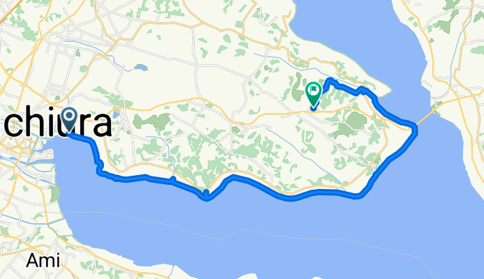
つくば霞ヶ浦りんりんロード, 土浦市へ岩坪, かすみがうら市
A cycling route starting in Ami, Ibaraki, Japan.
Overview
About this route
- 2 h 3 min
- Duration
- 27.1 km
- Distance
- 149 m
- Ascent
- 123 m
- Descent
- 13.2 km/h
- Avg. speed
- 37 m
- Max. altitude
Route photos


Continue with Bikemap
Use, edit, or download this cycling route
You would like to ride つくば霞ヶ浦りんりんロード, 土浦市へ岩坪, かすみがうら市 or customize it for your own trip? Here is what you can do with this Bikemap route:
Free features
- Save this route as favorite or in collections
- Copy & plan your own version of this route
- Sync your route with Garmin or Wahoo
Premium features
Free trial for 3 days, or one-time payment. More about Bikemap Premium.
- Navigate this route on iOS & Android
- Export a GPX / KML file of this route
- Create your custom printout (try it for free)
- Download this route for offline navigation
Discover more Premium features.
Get Bikemap PremiumFrom our community
Other popular routes starting in Ami
 20210606_霞ヶ浦一周サイクリング大会
- Distance
- 94.4 km
- Ascent
- 116 m
- Descent
- 116 m
- Location
- Ami, Ibaraki, Japan
 2136-1, Kunocho, Ushiku to 2-11, Koshiba 1-Chōme, Ryugasaki
- Distance
- 11.4 km
- Ascent
- 131 m
- Descent
- 132 m
- Location
- Ami, Ibaraki, Japan
 20230604_霞ヶ浦一周サイクリング大会
- Distance
- 124.4 km
- Ascent
- 205 m
- Descent
- 205 m
- Location
- Ami, Ibaraki, Japan
 Cycle 6: Tsuchiura - Tokyo !!!
- Distance
- 71.2 km
- Ascent
- 110 m
- Descent
- 110 m
- Location
- Ami, Ibaraki, Japan
 Kasumigaura cycle road
- Distance
- 92.3 km
- Ascent
- 10 m
- Descent
- 8 m
- Location
- Ami, Ibaraki, Japan
 雪印メグミルク工場見学とブルーベリー狩りコース
- Distance
- 25 km
- Ascent
- 169 m
- Descent
- 169 m
- Location
- Ami, Ibaraki, Japan
- つくば霞ヶ浦りんりんロード, 土浦市へ岩坪, かすみがうら市
- Distance
- 27.1 km
- Ascent
- 149 m
- Descent
- 123 m
- Location
- Ami, Ibaraki, Japan
 【DNS】20240602_K1「霞ヶ浦フルコース」推奨ルート
- Distance
- 122.3 km
- Ascent
- 186 m
- Descent
- 186 m
- Location
- Ami, Ibaraki, Japan
Open it in the app