
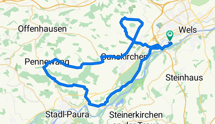
Wels - Riethal - Pennewang - Wels
A cycling route starting in Thalheim bei Wels, Upper Austria, Austria.
Overview
About this route
Eine wunderschöne Runde, ausgehend von Wels/West. Über die "Toskana von Wels", die in einer "Ehrenrunde" gestrift wird und vorbei an den bekannten Höfen im Westen von Wels geht, führt der Weg immer auf Asphaltstraßen nach Gunskirchen. Von dort weiter westwärts nach Pennewang, wo es wieder auf den Heimweg geht. Kurz nach Pennewang ist auch der einzige wirkliche Anstieg in dieser Runde, die weiter über Edt/Lambach und danach den Radweg zurück nach Wels führt.
Landschaftlich wunderbar, an eher verkehrsruhigen Straßen und vorbei an sehenswerten Dörfern und Bauernhöfen. Wirklich sehr schöne Runde.
- 2 h 32 min
- Duration
- 41.3 km
- Distance
- 182 m
- Ascent
- 184 m
- Descent
- 16.3 km/h
- Avg. speed
- 434 m
- Max. altitude

Route quality
Waytypes & surfaces along the route
Waytypes
Quiet road
20.3 km
(49 %)
Road
10.7 km
(26 %)
Surfaces
Paved
7.4 km
(18 %)
Unpaved
1.2 km
(3 %)
Asphalt
7.4 km
(18 %)
Unpaved (undefined)
1.2 km
(3 %)
Undefined
32.6 km
(79 %)
Continue with Bikemap
Use, edit, or download this cycling route
You would like to ride Wels - Riethal - Pennewang - Wels or customize it for your own trip? Here is what you can do with this Bikemap route:
Free features
- Save this route as favorite or in collections
- Copy & plan your own version of this route
- Sync your route with Garmin or Wahoo
Premium features
Free trial for 3 days, or one-time payment. More about Bikemap Premium.
- Navigate this route on iOS & Android
- Export a GPX / KML file of this route
- Create your custom printout (try it for free)
- Download this route for offline navigation
Discover more Premium features.
Get Bikemap PremiumFrom our community
Other popular routes starting in Thalheim bei Wels
 WÖS CALLING
- Distance
- 239.3 km
- Ascent
- 124 m
- Descent
- 254 m
- Location
- Thalheim bei Wels, Upper Austria, Austria
 Wels nach Leonding
- Distance
- 31.7 km
- Ascent
- 71 m
- Descent
- 113 m
- Location
- Thalheim bei Wels, Upper Austria, Austria
 Wels Messe - Sipbachzell - Golfplatz Kematen adK Ritzlhof - Haid - Marchtrenk - Wels
- Distance
- 62.9 km
- Ascent
- 523 m
- Descent
- 521 m
- Location
- Thalheim bei Wels, Upper Austria, Austria
 Von Wels bis Schlüßlberg
- Distance
- 17.6 km
- Ascent
- 357 m
- Descent
- 345 m
- Location
- Thalheim bei Wels, Upper Austria, Austria
 Wels nach Linz Magdalena2
- Distance
- 40.3 km
- Ascent
- 95 m
- Descent
- 145 m
- Location
- Thalheim bei Wels, Upper Austria, Austria
 Almsee-Tour
- Distance
- 115.1 km
- Ascent
- 1,349 m
- Descent
- 1,348 m
- Location
- Thalheim bei Wels, Upper Austria, Austria
 Wels - Riethal - Pennewang - Wels
- Distance
- 41.4 km
- Ascent
- 182 m
- Descent
- 184 m
- Location
- Thalheim bei Wels, Upper Austria, Austria
 WelsWest-Scharten(Roithen)-WelsWest
- Distance
- 45.6 km
- Ascent
- 568 m
- Descent
- 564 m
- Location
- Thalheim bei Wels, Upper Austria, Austria
Open it in the app