
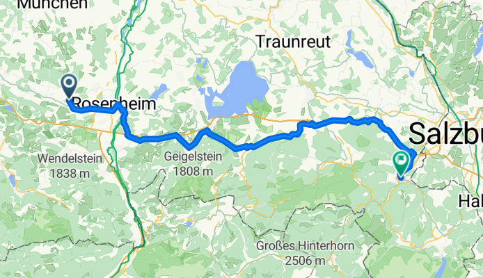
Rosenheim - Teisendorf
A cycling route starting in Bad Aibling, Bavaria, Germany.
Overview
About this route
- 5 h 49 min
- Duration
- 99.3 km
- Distance
- 1,052 m
- Ascent
- 1,065 m
- Descent
- 17.1 km/h
- Avg. speed
- 741 m
- Max. altitude

Route quality
Waytypes & surfaces along the route
Waytypes
Path
43.7 km
(44 %)
Quiet road
30.8 km
(31 %)
Surfaces
Paved
82.4 km
(83 %)
Unpaved
6 km
(6 %)
Asphalt
81.4 km
(82 %)
Loose gravel
4 km
(4 %)
Continue with Bikemap
Use, edit, or download this cycling route
You would like to ride Rosenheim - Teisendorf or customize it for your own trip? Here is what you can do with this Bikemap route:
Free features
- Save this route as favorite or in collections
- Copy & plan your own version of this route
- Split it into stages to create a multi-day tour
- Sync your route with Garmin or Wahoo
Premium features
Free trial for 3 days, or one-time payment. More about Bikemap Premium.
- Navigate this route on iOS & Android
- Export a GPX / KML file of this route
- Create your custom printout (try it for free)
- Download this route for offline navigation
Discover more Premium features.
Get Bikemap PremiumFrom our community
Other popular routes starting in Bad Aibling
 Von Baum zu Baum - Tour 1 - Süd
- Distance
- 61.8 km
- Ascent
- 900 m
- Descent
- 900 m
- Location
- Bad Aibling, Bavaria, Germany
 Willing-Rastkapelle-Tregleralm
- Distance
- 34.8 km
- Ascent
- 570 m
- Descent
- 569 m
- Location
- Bad Aibling, Bavaria, Germany
 Rosenheim - Teisendorf
- Distance
- 99.3 km
- Ascent
- 1,052 m
- Descent
- 1,065 m
- Location
- Bad Aibling, Bavaria, Germany
 25D3A: Bad Aibling - Westerham 3
- Distance
- 16.9 km
- Ascent
- 82 m
- Descent
- 32 m
- Location
- Bad Aibling, Bavaria, Germany
 Ellmosen - Sachrang - Aschau
- Distance
- 100.1 km
- Ascent
- 479 m
- Descent
- 478 m
- Location
- Bad Aibling, Bavaria, Germany
 Bad Aibling Wirtsalm
- Distance
- 19.4 km
- Ascent
- 418 m
- Descent
- 92 m
- Location
- Bad Aibling, Bavaria, Germany
 Samerweg
- Distance
- 21.9 km
- Ascent
- 179 m
- Descent
- 53 m
- Location
- Bad Aibling, Bavaria, Germany
 Kurze Route zur Rastkapelle
- Distance
- 12.1 km
- Ascent
- 301 m
- Descent
- 48 m
- Location
- Bad Aibling, Bavaria, Germany
Open it in the app