
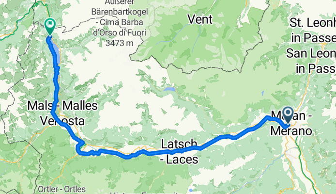
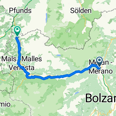
inv, Merano valle resia
A cycling route starting in Merano, Trentino-Alto Adige, Italy.
Overview
About this route
- 4 h 39 min
- Duration
- 80.2 km
- Distance
- 1,897 m
- Ascent
- 681 m
- Descent
- 17.3 km/h
- Avg. speed
- 1,553 m
- Max. altitude

Route quality
Waytypes & surfaces along the route
Waytypes
Cycleway
32.1 km
(40 %)
Quiet road
19.2 km
(24 %)
Surfaces
Paved
74.6 km
(93 %)
Unpaved
4.8 km
(6 %)
Asphalt
74.6 km
(93 %)
Loose gravel
4 km
(5 %)
Continue with Bikemap
Use, edit, or download this cycling route
You would like to ride inv, Merano valle resia or customize it for your own trip? Here is what you can do with this Bikemap route:
Free features
- Save this route as favorite or in collections
- Copy & plan your own version of this route
- Split it into stages to create a multi-day tour
- Sync your route with Garmin or Wahoo
Premium features
Free trial for 3 days, or one-time payment. More about Bikemap Premium.
- Navigate this route on iOS & Android
- Export a GPX / KML file of this route
- Create your custom printout (try it for free)
- Download this route for offline navigation
Discover more Premium features.
Get Bikemap PremiumFrom our community
Other popular routes starting in Merano
 inv, Merano valle resia
- Distance
- 80.2 km
- Ascent
- 1,897 m
- Descent
- 681 m
- Location
- Merano, Trentino-Alto Adige, Italy
 1.7. Merano - Trento
- Distance
- 88.9 km
- Ascent
- 208 m
- Descent
- 322 m
- Location
- Merano, Trentino-Alto Adige, Italy
 AXS Tour de Alps 2009 - Stage 8°
- Distance
- 185.6 km
- Ascent
- 4,708 m
- Descent
- 4,733 m
- Location
- Merano, Trentino-Alto Adige, Italy
 TRANSALP TAG 3 (Meran-Tramin)
- Distance
- 91 km
- Ascent
- 1,537 m
- Descent
- 1,599 m
- Location
- Merano, Trentino-Alto Adige, Italy
 07_Mals-Meran_13-310_SchlossTirol
- Distance
- 12.6 km
- Ascent
- 331 m
- Descent
- 332 m
- Location
- Merano, Trentino-Alto Adige, Italy
 Stage 16: In Pantani's Wheeltracks
- Distance
- 195.2 km
- Ascent
- 4,740 m
- Descent
- 3,876 m
- Location
- Merano, Trentino-Alto Adige, Italy
 Arnsdorfer Straße nach Romstraße
- Distance
- 518.7 km
- Ascent
- 9,099 m
- Descent
- 9,099 m
- Location
- Merano, Trentino-Alto Adige, Italy
 Via del Bastione nach Bozen
- Distance
- 30.2 km
- Ascent
- 41 m
- Descent
- 104 m
- Location
- Merano, Trentino-Alto Adige, Italy
Open it in the app