
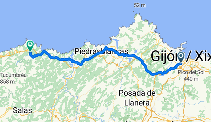
Overview
About this route
- dan, pregledano 31.8.25
- 3 h 30 min
- Duration
- 55.8 km
- Distance
- 1,171 m
- Ascent
- 1,172 m
- Descent
- 16 km/h
- Avg. speed
- 186 m
- Max. altitude

Part of
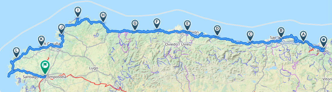
Camino del Norte tour
14 stages
Route quality
Waytypes & surfaces along the route
Waytypes
Cycleway
24.2 km
(43 %)
Road
14.3 km
(26 %)
Surfaces
Paved
40.2 km
(72 %)
Unpaved
0 km
(<1 %)
Asphalt
40.1 km
(72 %)
Concrete
0 km
(<1 %)
Continue with Bikemap
Use, edit, or download this cycling route
You would like to ride CN_06_28 or customize it for your own trip? Here is what you can do with this Bikemap route:
Free features
- Save this route as favorite or in collections
- Copy & plan your own version of this route
- Sync your route with Garmin or Wahoo
Premium features
Free trial for 3 days, or one-time payment. More about Bikemap Premium.
- Navigate this route on iOS & Android
- Export a GPX / KML file of this route
- Create your custom printout (try it for free)
- Download this route for offline navigation
Discover more Premium features.
Get Bikemap PremiumFrom our community
Other popular routes starting in Natahoyo
 Gijón-Santiago
- Distance
- 318.8 km
- Ascent
- 1,509 m
- Descent
- 1,236 m
- Location
- Natahoyo, Principality of Asturias, Spain
 Gijon - Nantes
- Distance
- 1,267.4 km
- Ascent
- 1,024 m
- Descent
- 1,014 m
- Location
- Natahoyo, Principality of Asturias, Spain
 XATADA PYNOSPERDIUS
- Distance
- 114.3 km
- Ascent
- 2,632 m
- Descent
- 2,635 m
- Location
- Natahoyo, Principality of Asturias, Spain
![Vuelta a Asturias 2010 - Et.03. 1ºSector [Gijon - Aviles]](https://media.bikemap.net/routes/585301/staticmaps/in_8ab1d5f9-292a-49df-8920-335db6124f1c_400x400_bikemap-2021-3D-static.png) Vuelta a Asturias 2010 - Et.03. 1ºSector [Gijon - Aviles]
Vuelta a Asturias 2010 - Et.03. 1ºSector [Gijon - Aviles]- Distance
- 89.3 km
- Ascent
- 954 m
- Descent
- 964 m
- Location
- Natahoyo, Principality of Asturias, Spain
 SALIDA PYNOSPERDIUS 24/03/12
- Distance
- 105.7 km
- Ascent
- 2,170 m
- Descent
- 2,177 m
- Location
- Natahoyo, Principality of Asturias, Spain
 Playas de Gijón
- Distance
- 4 km
- Ascent
- 74 m
- Descent
- 76 m
- Location
- Natahoyo, Principality of Asturias, Spain
 Via Verde - Senda de La Camocha
- Distance
- 10.7 km
- Ascent
- 143 m
- Descent
- 73 m
- Location
- Natahoyo, Principality of Asturias, Spain
 El cabo de Peñas
- Distance
- 97.1 km
- Ascent
- 786 m
- Descent
- 786 m
- Location
- Natahoyo, Principality of Asturias, Spain
Open it in the app