Kleine Blumberg Route auf geteerten Straßen und Wegen
A cycling route starting in Blumberg, Baden-Württemberg, Germany.
Overview
About this route
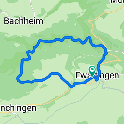
Blumberg-Achdorf-Eschach+Opferdingen-Riedböhringen-Blumberg
- -:--
- Duration
- 15.3 km
- Distance
- 268 m
- Ascent
- 268 m
- Descent
- ---
- Avg. speed
- ---
- Avg. speed
Route quality
Waytypes & surfaces along the route
Waytypes
Road
10 km
(65 %)
Quiet road
3 km
(19 %)
Surfaces
Paved
14.3 km
(93 %)
Asphalt
13 km
(85 %)
Paved (undefined)
1.3 km
(8 %)
Undefined
1 km
(7 %)
Route highlights
Points of interest along the route
Point of interest after 9 km
Point of interest after 9.2 km
Continue with Bikemap
Use, edit, or download this cycling route
You would like to ride Kleine Blumberg Route auf geteerten Straßen und Wegen or customize it for your own trip? Here is what you can do with this Bikemap route:
Free features
- Save this route as favorite or in collections
- Copy & plan your own version of this route
- Sync your route with Garmin or Wahoo
Premium features
Free trial for 3 days, or one-time payment. More about Bikemap Premium.
- Navigate this route on iOS & Android
- Export a GPX / KML file of this route
- Create your custom printout (try it for free)
- Download this route for offline navigation
Discover more Premium features.
Get Bikemap PremiumFrom our community
Other popular routes starting in Blumberg
- Blumberg-Schluchsee-Todtnau-Kirchzarten-Thurner-Neustadt-Bonndorf-Blumberg
- Distance
- 170.7 km
- Ascent
- 2,409 m
- Descent
- 2,409 m
- Location
- Blumberg, Baden-Württemberg, Germany
- Mundelfingen Hausen Achdorf
- Distance
- 19.7 km
- Ascent
- 337 m
- Descent
- 337 m
- Location
- Blumberg, Baden-Württemberg, Germany
- Kleine Blumberg Route auf geteerten Straßen und Wegen
- Distance
- 15.3 km
- Ascent
- 260 m
- Descent
- 262 m
- Location
- Blumberg, Baden-Württemberg, Germany
- Schluchtensteig Schwarzwald Etappe 2 von Blumberg zur Schattenmühle
- Distance
- 20.3 km
- Ascent
- 820 m
- Descent
- 869 m
- Location
- Blumberg, Baden-Württemberg, Germany
- Wutachschlucht 12,5 Km
- Distance
- 12.5 km
- Ascent
- 483 m
- Descent
- 386 m
- Location
- Blumberg, Baden-Württemberg, Germany
- Wutachtal Donau Aitrachtal
- Distance
- 44 km
- Ascent
- 462 m
- Descent
- 367 m
- Location
- Blumberg, Baden-Württemberg, Germany
- K6511 9, Wutach nach K6511 9, Wutach
- Distance
- 27.3 km
- Ascent
- 867 m
- Descent
- 864 m
- Location
- Blumberg, Baden-Württemberg, Germany
- Kleine Blumberg Route auf geteerten Straßen und Wegen
- Distance
- 15.3 km
- Ascent
- 268 m
- Descent
- 268 m
- Location
- Blumberg, Baden-Württemberg, Germany
Open it in the app