

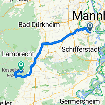
LU-Rotsteig-R58-LU
A cycling route starting in Neuhofen, Rhineland-Palatinate, Germany.
Overview
About this route
Gentle steady ascent to the Kurpfalz Park with a small steep ramp just before the park. Return via the R58 mostly through woods and meadows, partly along the stream. Very nice to ride.
- -:--
- Duration
- 79 km
- Distance
- 609 m
- Ascent
- 602 m
- Descent
- ---
- Avg. speed
- 369 m
- Max. altitude
Route quality
Waytypes & surfaces along the route
Waytypes
Track
26.9 km
(34 %)
Path
16.6 km
(21 %)
Surfaces
Paved
52.9 km
(67 %)
Unpaved
18.2 km
(23 %)
Asphalt
50.6 km
(64 %)
Gravel
11.1 km
(14 %)
Continue with Bikemap
Use, edit, or download this cycling route
You would like to ride LU-Rotsteig-R58-LU or customize it for your own trip? Here is what you can do with this Bikemap route:
Free features
- Save this route as favorite or in collections
- Copy & plan your own version of this route
- Sync your route with Garmin or Wahoo
Premium features
Free trial for 3 days, or one-time payment. More about Bikemap Premium.
- Navigate this route on iOS & Android
- Export a GPX / KML file of this route
- Create your custom printout (try it for free)
- Download this route for offline navigation
Discover more Premium features.
Get Bikemap PremiumFrom our community
Other popular routes starting in Neuhofen
 LU-Rotsteig-R58-LU
- Distance
- 79 km
- Ascent
- 609 m
- Descent
- 602 m
- Location
- Neuhofen, Rhineland-Palatinate, Germany
 Strandbadweg 1, Mannheim nach Chemin des Mouettes, Lauterbourg
- Distance
- 81.2 km
- Ascent
- 328 m
- Descent
- 306 m
- Location
- Neuhofen, Rhineland-Palatinate, Germany
 Kalmithaus
- Distance
- 46.7 km
- Ascent
- 890 m
- Descent
- 330 m
- Location
- Neuhofen, Rhineland-Palatinate, Germany
 Bingen am Rhein - Sankt Leon-Rot
- Distance
- 129.4 km
- Ascent
- 992 m
- Descent
- 863 m
- Location
- Neuhofen, Rhineland-Palatinate, Germany
 Mannheim to Stromberg Camping to Cannstatter Wason Stuttgart
- Distance
- 116.3 km
- Ascent
- 475 m
- Descent
- 349 m
- Location
- Neuhofen, Rhineland-Palatinate, Germany
 Eichelgarten 26, Neuhofen nach Jahnstraße 20, Neuhofen
- Distance
- 23.5 km
- Ascent
- 73 m
- Descent
- 65 m
- Location
- Neuhofen, Rhineland-Palatinate, Germany
 Ludwigshafen - Speyer - Ludwigshafen CLONED FROM ROUTE 27269
- Distance
- 52.9 km
- Ascent
- 67 m
- Descent
- 62 m
- Location
- Neuhofen, Rhineland-Palatinate, Germany
 Azaleenweg nach Seewaldsiedlung
- Distance
- 21.2 km
- Ascent
- 48 m
- Descent
- 53 m
- Location
- Neuhofen, Rhineland-Palatinate, Germany
Open it in the app