

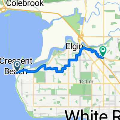
Ocean Park Rd, Surrey to Ocean Park Rd, Surrey
A cycling route starting in White Rock, British Columbia, Canada.
Overview
About this route
- 1 h 8 min
- Duration
- 13.3 km
- Distance
- 178 m
- Ascent
- 185 m
- Descent
- 11.7 km/h
- Avg. speed
- 77 m
- Max. altitude

Route photos


Route quality
Waytypes & surfaces along the route
Waytypes
Road
8.8 km
(66 %)
Quiet road
2.5 km
(19 %)
Surfaces
Paved
11.8 km
(89 %)
Unpaved
1.3 km
(10 %)
Asphalt
11.7 km
(88 %)
Loose gravel
1.2 km
(9 %)
Continue with Bikemap
Use, edit, or download this cycling route
You would like to ride Ocean Park Rd, Surrey to Ocean Park Rd, Surrey or customize it for your own trip? Here is what you can do with this Bikemap route:
Free features
- Save this route as favorite or in collections
- Copy & plan your own version of this route
- Sync your route with Garmin or Wahoo
Premium features
Free trial for 3 days, or one-time payment. More about Bikemap Premium.
- Navigate this route on iOS & Android
- Export a GPX / KML file of this route
- Create your custom printout (try it for free)
- Download this route for offline navigation
Discover more Premium features.
Get Bikemap PremiumFrom our community
Other popular routes starting in White Rock
 The Beach Loop
- Distance
- 23.4 km
- Ascent
- 252 m
- Descent
- 252 m
- Location
- White Rock, British Columbia, Canada
- Ocean Park Rd, Surrey to Ocean Park Rd, Surrey
- Distance
- 13.3 km
- Ascent
- 178 m
- Descent
- 185 m
- Location
- White Rock, British Columbia, Canada
 Steady ride in Surrey
- Distance
- 7.8 km
- Ascent
- 106 m
- Descent
- 116 m
- Location
- White Rock, British Columbia, Canada
 028 panamericana
- Distance
- 161.2 km
- Ascent
- 566 m
- Descent
- 532 m
- Location
- White Rock, British Columbia, Canada
 Greenway round trip
- Distance
- 46 km
- Ascent
- 344 m
- Descent
- 340 m
- Location
- White Rock, British Columbia, Canada
 Recovered Route
- Distance
- 19.5 km
- Ascent
- 16 m
- Descent
- 119 m
- Location
- White Rock, British Columbia, Canada
 Beecher St, Surrey to 32 Ave, Surrey
- Distance
- 9.1 km
- Ascent
- 154 m
- Descent
- 118 m
- Location
- White Rock, British Columbia, Canada
 King George Blvd, Surrey to Ocean Park Rd, Surrey
- Distance
- 10 km
- Ascent
- 73 m
- Descent
- 131 m
- Location
- White Rock, British Columbia, Canada
Open it in the app