
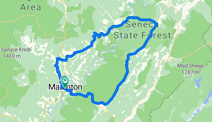
Marlinton Loop
A cycling route starting in Marlinton, West Virginia, United States.
Overview
About this route
- 3 h 14 min
- Duration
- 63.5 km
- Distance
- 1,209 m
- Ascent
- 1,208 m
- Descent
- 19.6 km/h
- Avg. speed
- 935 m
- Max. altitude
Route photos


Route quality
Waytypes & surfaces along the route
Waytypes
Road
33 km
(52 %)
Quiet road
2.5 km
(4 %)
Undefined
27.9 km
(44 %)
Surfaces
Paved
33.6 km
(53 %)
Paved (undefined)
19 km
(30 %)
Asphalt
14.6 km
(23 %)
Undefined
29.8 km
(47 %)
Route highlights
Points of interest along the route
Point of interest after 18.7 km
The Loop
Drinking water after 37.9 km
Outside faucet on the building behind the office of Seneca State Forest.
Continue with Bikemap
Use, edit, or download this cycling route
You would like to ride Marlinton Loop or customize it for your own trip? Here is what you can do with this Bikemap route:
Free features
- Save this route as favorite or in collections
- Copy & plan your own version of this route
- Sync your route with Garmin or Wahoo
Premium features
Free trial for 3 days, or one-time payment. More about Bikemap Premium.
- Navigate this route on iOS & Android
- Export a GPX / KML file of this route
- Create your custom printout (try it for free)
- Download this route for offline navigation
Discover more Premium features.
Get Bikemap PremiumFrom our community
Other popular routes starting in Marlinton
 Marlinton-Cloverlick Loop
- Distance
- 62.8 km
- Ascent
- 537 m
- Descent
- 537 m
- Location
- Marlinton, West Virginia, United States
 Clover Lick - Green Bank
- Distance
- 50.3 km
- Ascent
- 546 m
- Descent
- 546 m
- Location
- Marlinton, West Virginia, United States
 Clover Lick - Observatory Route
- Distance
- 64.9 km
- Ascent
- 552 m
- Descent
- 555 m
- Location
- Marlinton, West Virginia, United States
 Three-Mountain Ride CLONED FROM ROUTE 216425
- Distance
- 110.7 km
- Ascent
- 1,909 m
- Descent
- 1,711 m
- Location
- Marlinton, West Virginia, United States
 Hillsboro - Droop - Locust Creek Loop
- Distance
- 28.6 km
- Ascent
- 421 m
- Descent
- 421 m
- Location
- Marlinton, West Virginia, United States
 Upper Scenic Highway Map
- Distance
- 39.7 km
- Ascent
- 828 m
- Descent
- 828 m
- Location
- Marlinton, West Virginia, United States
 Lobelia Loop
- Distance
- 39.3 km
- Ascent
- 690 m
- Descent
- 690 m
- Location
- Marlinton, West Virginia, United States
 AML (over the ridge)
- Distance
- 92.8 km
- Ascent
- 1,694 m
- Descent
- 1,649 m
- Location
- Marlinton, West Virginia, United States
Open it in the app