
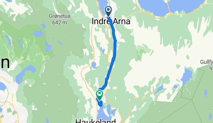
Arna nach Lone Camping Tag 13
A cycling route starting in Indre Arna, Hordaland, Norway.
Overview
About this route
- 29 min
- Duration
- 7 km
- Distance
- 91 m
- Ascent
- 26 m
- Descent
- 14.5 km/h
- Avg. speed
- 134 m
- Max. altitude

Route photos


Continue with Bikemap
Use, edit, or download this cycling route
You would like to ride Arna nach Lone Camping Tag 13 or customize it for your own trip? Here is what you can do with this Bikemap route:
Free features
- Save this route as favorite or in collections
- Copy & plan your own version of this route
- Sync your route with Garmin or Wahoo
Premium features
Free trial for 3 days, or one-time payment. More about Bikemap Premium.
- Navigate this route on iOS & Android
- Export a GPX / KML file of this route
- Create your custom printout (try it for free)
- Download this route for offline navigation
Discover more Premium features.
Get Bikemap PremiumFrom our community
Other popular routes starting in Indre Arna
 utkast
- Distance
- 686.7 km
- Ascent
- 14,274 m
- Descent
- 14,310 m
- Location
- Indre Arna, Hordaland, Norway
 01.07 Trengereid - Bergen Camp
- Distance
- 24.9 km
- Ascent
- 0 m
- Descent
- 0 m
- Location
- Indre Arna, Hordaland, Norway
- Arna nach Lone Camping Tag 13
- Distance
- 7 km
- Ascent
- 91 m
- Descent
- 26 m
- Location
- Indre Arna, Hordaland, Norway
 Tour de Osterøy
- Distance
- 87.6 km
- Ascent
- 1,418 m
- Descent
- 1,422 m
- Location
- Indre Arna, Hordaland, Norway
 Tour of Norway stage 21 Trengereid - Stanghelle
- Distance
- 21.9 km
- Ascent
- 1,202 m
- Descent
- 1,165 m
- Location
- Indre Arna, Hordaland, Norway
 Arna Osterøy
- Distance
- 91 km
- Ascent
- 0 m
- Descent
- 0 m
- Location
- Indre Arna, Hordaland, Norway
 Bergen to Kvanndal
- Distance
- 91.5 km
- Ascent
- 2,540 m
- Descent
- 2,580 m
- Location
- Indre Arna, Hordaland, Norway
 Osterøy, Fotlandsvåg-runden og Hamrerunden
- Distance
- 90.1 km
- Ascent
- 2,332 m
- Descent
- 2,332 m
- Location
- Indre Arna, Hordaland, Norway
Open it in the app