hotel cepina cancano passo trela val vezzola
- 48.6 km
- 1,259 m
- 1,259 m
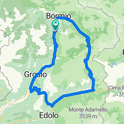
- Valdisotto, Lombardy, Italy
A cycling route starting in Valdisotto, Lombardy, Italy.
Overview
Do you like to ride uphill because then you enjoy a great descent? This route is for your wheels about 3:00 the complete loop. A gentle but steady climb. The ascent to Cancano is smooth and pleasant, arriving at the Fraele towers. Once you've crossed the wall of the San Giacomo dam, you climb to the Solena picnic area and then descend along a beautiful dirt road; the descent from Bosco Piano is particularly fun and suitable for everyone. A very slight climb is the price to pay to hook onto the Stelvio road just above the Bagni Vecchi. Book your cycling holiday at the Hotel Cepina****, which is open all year round. www.hotelcepina.it info@hotelcepina.it +39 0342951161 It will be a pleasure to cycle with you to accompany you only to the most beautiful places. Stefano
created this 13 years ago
Route quality
Quiet road
17.4 km
(45 %)
Track
5.8 km
(15 %)
Paved
19.7 km
(51 %)
Unpaved
9.3 km
(24 %)
Asphalt
19.7 km
(51 %)
Ground
5.8 km
(15 %)
Route highlights
area pic nic solena. attrezzata con BBQ, legname facilmente reperibile
Continue with Bikemap
You would like to ride Bosco Piano or customize it for your own trip? Here is what you can do with this Bikemap route:
Free trial for 3 days, or one-time payment. More about Bikemap Premium.
Discover more Premium features.
Get Bikemap PremiumFrom our community
Open it in the app