
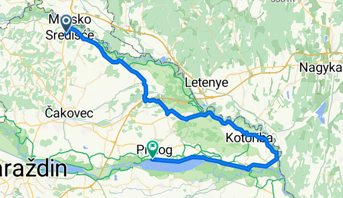
Mur07a_MurskoSredišće_Prelog 71,1km 100hm
A cycling route starting in Peklenica, Međimurska Županija, Croatia.
Overview
About this route
- 3 h 38 min
- Duration
- 69.8 km
- Distance
- 60 m
- Ascent
- 86 m
- Descent
- 19.2 km/h
- Avg. speed
- 182 m
- Max. altitude

Route quality
Waytypes & surfaces along the route
Waytypes
Road
17.3 km
(25 %)
Access road
8.5 km
(12 %)
Surfaces
Paved
50.9 km
(73 %)
Unpaved
5.1 km
(7 %)
Asphalt
39.8 km
(57 %)
Concrete
11.1 km
(16 %)
Route highlights
Points of interest along the route
Drinking water after 0.9 km
Bäcker?
Accommodation after 1 km
Bäcker
Accommodation after 1 km
Bäcker
Drinking water after 1 km
Bänke
Accommodation after 1 km
Cafe - Frühstück?
Drinking water after 4.9 km
Bank
Photo after 5.1 km
Beautiful wayside shrine
Photo after 6.8 km
Hier geht der offizielle Murradweg zum Fluß - die Markierung folgt der Straßenversion. Dort ist vermutlich nur ein Schotterweg - in welchem Zustand auch immer
Photo after 8 km
Photo after 12.4 km
Kirche von Podturen
Drinking water after 15.6 km
Bank
Accommodation after 17.7 km
Gelateria Dějá Vu - Eiscafe
Photo after 19.6 km
Marterl
Photo after 22.5 km
Statuen von Maria und Josef auf der Flucht nach Ägypten
Photo after 27.8 km
Goričana
Photo after 28.2 km
Marterl
Photo after 32.5 km
Murauen-Schotterweg
Photo after 39.1 km
Lebensraum der Europäischen Sumpfschildkröte – Amazon of Europe Bike Trail, Regionalpark Mura-Drava
Drinking water after 46.9 km
Rastplatz an der Mur
Photo after 47.1 km
Ende des Murradwegs 🚴♂️
Photo after 47.1 km
Aussichtspunkt Mur Mündung in die Drau
Photo after 47.1 km
Aussichtsturm und Rastplatz
Photo after 49.1 km
Blue Bird Mural in Legrad
Photo after 52.5 km
Zum Aussichtspunkt der Mur-Mündung in die Drau hier über die Drau fahren. Sind aber 20km Umweg
Photo after 57.7 km
Wasserkraftwerk Sveta Marija
Photo after 60.7 km
Je nachdem, wo der Weg besser ist fahren. Nach den Bildern vermutlich näher am Wasser
Photo after 61.1 km
Dubravsko-Stausee-Dammweg
Continue with Bikemap
Use, edit, or download this cycling route
You would like to ride Mur07a_MurskoSredišće_Prelog 71,1km 100hm or customize it for your own trip? Here is what you can do with this Bikemap route:
Free features
- Save this route as favorite or in collections
- Copy & plan your own version of this route
- Sync your route with Garmin or Wahoo
Premium features
Free trial for 3 days, or one-time payment. More about Bikemap Premium.
- Navigate this route on iOS & Android
- Export a GPX / KML file of this route
- Create your custom printout (try it for free)
- Download this route for offline navigation
Discover more Premium features.
Get Bikemap PremiumFrom our community
Other popular routes starting in Peklenica
 MS - Bad Radkersburg - MS
- Distance
- 99.1 km
- Ascent
- 110 m
- Descent
- 110 m
- Location
- Peklenica, Međimurska Županija, Croatia
 Short - 2 HTs(Z. Gora, Jurovcak)
- Distance
- 37.6 km
- Ascent
- 286 m
- Descent
- 289 m
- Location
- Peklenica, Međimurska Županija, Croatia
 Središće-Štrigova-Toplice-Selnica
- Distance
- 27.5 km
- Ascent
- 236 m
- Descent
- 232 m
- Location
- Peklenica, Međimurska Županija, Croatia
 L 17-hardcore
- Distance
- 25.1 km
- Ascent
- 74 m
- Descent
- 72 m
- Location
- Peklenica, Međimurska Županija, Croatia
 DG 6
DG 6- Distance
- 26.7 km
- Ascent
- 68 m
- Descent
- 64 m
- Location
- Peklenica, Međimurska Županija, Croatia
 Ruta kratka2 MS-MS
- Distance
- 34.7 km
- Ascent
- 356 m
- Descent
- 356 m
- Location
- Peklenica, Međimurska Županija, Croatia
 Mur07a_MurskoSredišće_Prelog 71,1km 100hm
- Distance
- 69.8 km
- Ascent
- 60 m
- Descent
- 86 m
- Location
- Peklenica, Međimurska Županija, Croatia
 DIRTY MINERS - DIRTY MINERS
- Distance
- 35.9 km
- Ascent
- 108 m
- Descent
- 105 m
- Location
- Peklenica, Međimurska Županija, Croatia
Open it in the app