
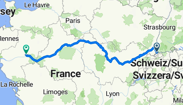
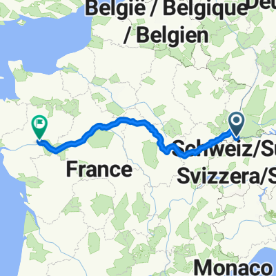
Basel to Angers
A cycling route starting in Basel, Canton of Basel-City, Switzerland.
Overview
About this route
- 56 h 42 min
- Duration
- 930.5 km
- Distance
- 4,082 m
- Ascent
- 4,313 m
- Descent
- 16.4 km/h
- Avg. speed
- 434 m
- Max. altitude
Route quality
Waytypes & surfaces along the route
Waytypes
Cycleway
251.2 km
(27 %)
Quiet road
241.9 km
(26 %)
Surfaces
Paved
614.1 km
(66 %)
Unpaved
93 km
(10 %)
Asphalt
576.9 km
(62 %)
Gravel
46.5 km
(5 %)
Route highlights
Points of interest along the route
Accommodation after 217.9 km
Dole - campsite and bakeries
Accommodation after 286.3 km
Municipal Campsite - Saint Marie sur Ouche
Accommodation after 342.5 km
Le Madriniacus camping pour randonneurs cyclistes Garden camping
Accommodation after 396.2 km
https://gravieredumoulin.lezinnes.fr/camping.php?lg=fr Campsite 3 stars
Accommodation after 464.9 km
https://camping.ville-joigny.fr/camping_2 Municipal Campsite
Accommodation after 526.2 km
Camping in the forest - 3 stars https://centrevaldeloire-mb-prestataire.for-system.com/f70133_fr-.aspx
Accommodation after 579.1 km
Camping L'isle aux moulins https://www.camping-jargeau.fr/en/home/
Accommodation after 635.9 km
Friendship campsite municipal https://centrevaldeloire-mb-prestataire.for-system.com/f71362_fr-.aspx
Point of interest after 686.3 km
Sauvage winery
Accommodation after 695.2 km
Camping les Patis https://www.wildbed.fr/
Accommodation after 739.8 km
Camping le Sabot https://camping-azay-le-rideau.fr/
Accommodation after 799.5 km
Camping Terre d'Entente https://terre-dentente.fr/
Continue with Bikemap
Use, edit, or download this cycling route
You would like to ride Basel to Angers or customize it for your own trip? Here is what you can do with this Bikemap route:
Free features
- Save this route as favorite or in collections
- Copy & plan your own version of this route
- Split it into stages to create a multi-day tour
- Sync your route with Garmin or Wahoo
Premium features
Free trial for 3 days, or one-time payment. More about Bikemap Premium.
- Navigate this route on iOS & Android
- Export a GPX / KML file of this route
- Create your custom printout (try it for free)
- Download this route for offline navigation
Discover more Premium features.
Get Bikemap PremiumFrom our community
Other popular routes starting in Basel
 Tag 1: Basel - Rothenburg LU
- Distance
- 99.6 km
- Ascent
- 1,282 m
- Descent
- 1,069 m
- Location
- Basel, Canton of Basel-City, Switzerland
 Basel-Blauen-Basel
- Distance
- 52.8 km
- Ascent
- 885 m
- Descent
- 882 m
- Location
- Basel, Canton of Basel-City, Switzerland
 Basel to Angers
- Distance
- 930.5 km
- Ascent
- 4,082 m
- Descent
- 4,313 m
- Location
- Basel, Canton of Basel-City, Switzerland
 Basel-Südschwarzwaldrunde
- Distance
- 53.9 km
- Ascent
- 406 m
- Descent
- 392 m
- Location
- Basel, Canton of Basel-City, Switzerland
 Moderate route in
- Distance
- 56.9 km
- Ascent
- 1,144 m
- Descent
- 1,127 m
- Location
- Basel, Canton of Basel-City, Switzerland
 Basel to Zurich
- Distance
- 94 km
- Ascent
- 922 m
- Descent
- 776 m
- Location
- Basel, Canton of Basel-City, Switzerland
 Basel out and back
- Distance
- 64.7 km
- Ascent
- 890 m
- Descent
- 893 m
- Location
- Basel, Canton of Basel-City, Switzerland
 Rührberg 2
- Distance
- 23.5 km
- Ascent
- 299 m
- Descent
- 297 m
- Location
- Basel, Canton of Basel-City, Switzerland
Open it in the app