

Horseshoe - Limestone Mt. Ride
A cycling route starting in Parsons, West Virginia, United States.
Overview
About this route
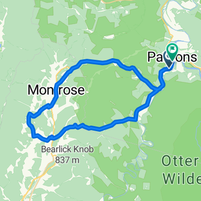
Lollypop Ride from Horseshoe Campground/Day use area, up Location Road and back Limestone Road. Major climb is seven miles from the river at St. George to topping out at the top, but varying grades and some flat and down hill so you legs get a break. You gain 1,851 for an average of 3.3%. First 2 miles averages 5.5% and last mile averages 8.2%.
Loop is 20.5 miles starting in St. George.
You get some great vistas on this ride!
0.0 Horseshoe Campground
3.9 Right on Holly Meadows Road Co. 1.
6.8 Right on Location Road. Co. 5 in St. George. Begin Climb.
15.6 Left on Co. 3 Limestone Road
27.3 Left in St. George and immediateig right onto Co. 1 to return to Horshoe.
30.3 Left on Co. 7 Horseshoe Run Road.
34.21 Finish.
- -:--
- Duration
- 55 km
- Distance
- 677 m
- Ascent
- 677 m
- Descent
- ---
- Avg. speed
- ---
- Max. altitude

Route quality
Waytypes & surfaces along the route
Waytypes
Quiet road
30.8 km
(56 %)
Road
24.2 km
(44 %)
Surfaces
Unpaved
6.6 km
(12 %)
Gravel
6.6 km
(12 %)
Undefined
48.4 km
(88 %)
Continue with Bikemap
Use, edit, or download this cycling route
You would like to ride Horseshoe - Limestone Mt. Ride or customize it for your own trip? Here is what you can do with this Bikemap route:
Free features
- Save this route as favorite or in collections
- Copy & plan your own version of this route
- Sync your route with Garmin or Wahoo
Premium features
Free trial for 3 days, or one-time payment. More about Bikemap Premium.
- Navigate this route on iOS & Android
- Export a GPX / KML file of this route
- Create your custom printout (try it for free)
- Download this route for offline navigation
Discover more Premium features.
Get Bikemap PremiumFrom our community
Other popular routes starting in Parsons
 Limestone Mt. Loop
- Distance
- 33.4 km
- Ascent
- 587 m
- Descent
- 587 m
- Location
- Parsons, West Virginia, United States
 Route in Hendricks
- Distance
- 83.8 km
- Ascent
- 1,531 m
- Descent
- 1,531 m
- Location
- Parsons, West Virginia, United States
 Allegheny Highlands Trail of Wv, Parsons to Main St, Parsons
- Distance
- 42.2 km
- Ascent
- 531 m
- Descent
- 527 m
- Location
- Parsons, West Virginia, United States
 Olson Fire Tower to Parsons
- Distance
- 35.8 km
- Ascent
- 96 m
- Descent
- 710 m
- Location
- Parsons, West Virginia, United States
 Texas Mountain
- Distance
- 34.7 km
- Ascent
- 502 m
- Descent
- 502 m
- Location
- Parsons, West Virginia, United States
 Bfalls to Moundsville
- Distance
- 201.5 km
- Ascent
- 1,391 m
- Descent
- 2,151 m
- Location
- Parsons, West Virginia, United States
 Pifer Mountain Loop
- Distance
- 31.4 km
- Ascent
- 557 m
- Descent
- 557 m
- Location
- Parsons, West Virginia, United States
 Horseshoe - Limestone Mt. Ride
- Distance
- 55 km
- Ascent
- 677 m
- Descent
- 677 m
- Location
- Parsons, West Virginia, United States
Open it in the app