
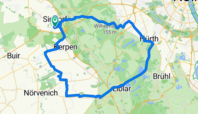
Moderate Route
A cycling route starting in Kerpen, North Rhine-Westphalia, Germany.
Overview
About this route
- 4 h 33 min
- Duration
- 62.1 km
- Distance
- 384 m
- Ascent
- 429 m
- Descent
- 13.7 km/h
- Avg. speed
- 126 m
- Max. altitude

Route photos


Route quality
Waytypes & surfaces along the route
Waytypes
Path
27.3 km
(44 %)
Track
12.4 km
(20 %)
Surfaces
Paved
52.2 km
(84 %)
Unpaved
3.1 km
(5 %)
Asphalt
47.2 km
(76 %)
Paved (undefined)
5 km
(8 %)
Continue with Bikemap
Use, edit, or download this cycling route
You would like to ride Moderate Route or customize it for your own trip? Here is what you can do with this Bikemap route:
Free features
- Save this route as favorite or in collections
- Copy & plan your own version of this route
- Sync your route with Garmin or Wahoo
Premium features
Free trial for 3 days, or one-time payment. More about Bikemap Premium.
- Navigate this route on iOS & Android
- Export a GPX / KML file of this route
- Create your custom printout (try it for free)
- Download this route for offline navigation
Discover more Premium features.
Get Bikemap PremiumFrom our community
Other popular routes starting in Kerpen
 Erftkreisrunde
- Distance
- 39.1 km
- Ascent
- 108 m
- Descent
- 109 m
- Location
- Kerpen, North Rhine-Westphalia, Germany
- Moderate Route
- Distance
- 62.1 km
- Ascent
- 384 m
- Descent
- 429 m
- Location
- Kerpen, North Rhine-Westphalia, Germany
 Kerpen - Bodensee I Bad Godesberg
- Distance
- 54.6 km
- Ascent
- 195 m
- Descent
- 200 m
- Location
- Kerpen, North Rhine-Westphalia, Germany
 Weyerstraße nach Thorrer Straße
- Distance
- 10.4 km
- Ascent
- 30 m
- Descent
- 93 m
- Location
- Kerpen, North Rhine-Westphalia, Germany
 Kerpen - Boxmeer
- Distance
- 130.9 km
- Ascent
- 346 m
- Descent
- 412 m
- Location
- Kerpen, North Rhine-Westphalia, Germany
 Bergheimer Acht
- Distance
- 58.9 km
- Ascent
- 120 m
- Descent
- 146 m
- Location
- Kerpen, North Rhine-Westphalia, Germany
 Kerpen - Mettmann
- Distance
- 74.3 km
- Ascent
- 332 m
- Descent
- 227 m
- Location
- Kerpen, North Rhine-Westphalia, Germany
 Erft-Radweg - von Sindorf zur Mündung
- Distance
- 59.5 km
- Ascent
- 27 m
- Descent
- 56 m
- Location
- Kerpen, North Rhine-Westphalia, Germany
Open it in the app