

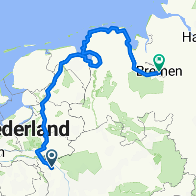
Düsseldorf - Oost-Vlieland
Emmerich - Hattem
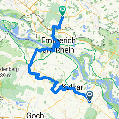
A cycling route starting in Kalkar, North Rhine-Westphalia, Germany.
Overview
About this route
- 5 h 44 min
- Duration
- 101.9 km
- Distance
- 274 m
- Ascent
- 289 m
- Descent
- 17.8 km/h
- Avg. speed
- 78 m
- Max. altitude

Part of
Düsseldorf - Oost-Vlieland
4 stages
Route quality
Waytypes & surfaces along the route
Waytypes
Cycleway
71.3 km
(70 %)
Quiet road
15.3 km
(15 %)
Surfaces
Paved
87.6 km
(86 %)
Asphalt
74.4 km
(73 %)
Concrete
10.2 km
(10 %)
Continue with Bikemap
Use, edit, or download this cycling route
You would like to ride Emmerich - Hattem or customize it for your own trip? Here is what you can do with this Bikemap route:
Free features
- Save this route as favorite or in collections
- Copy & plan your own version of this route
- Split it into stages to create a multi-day tour
- Sync your route with Garmin or Wahoo
Premium features
Free trial for 3 days, or one-time payment. More about Bikemap Premium.
- Navigate this route on iOS & Android
- Export a GPX / KML file of this route
- Create your custom printout (try it for free)
- Download this route for offline navigation
Discover more Premium features.
Get Bikemap PremiumFrom our community
Other popular routes starting in Kalkar
 Von Kalkar bis Bremen Version 1
- Distance
- 620.1 km
- Ascent
- 683 m
- Descent
- 734 m
- Location
- Kalkar, North Rhine-Westphalia, Germany
 Wissel Bocholt Wissel 80 km
- Distance
- 78.5 km
- Ascent
- 49 m
- Descent
- 50 m
- Location
- Kalkar, North Rhine-Westphalia, Germany
 Route zu Wunderland, Wisseler See, Kalkar Marktplatz, Mühle
- Distance
- 12 km
- Ascent
- 7 m
- Descent
- 7 m
- Location
- Kalkar, North Rhine-Westphalia, Germany
 Emmerich - Hattem
- Distance
- 101.9 km
- Ascent
- 274 m
- Descent
- 289 m
- Location
- Kalkar, North Rhine-Westphalia, Germany
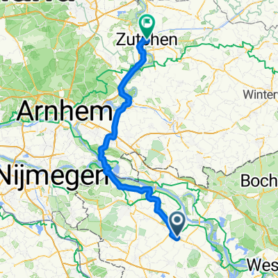 Kalkar - Zutphen
- Distance
- 73.3 km
- Ascent
- 29 m
- Descent
- 81 m
- Location
- Kalkar, North Rhine-Westphalia, Germany
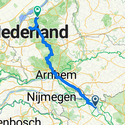
 Kalkar - ’s-Heerenberg
- Distance
- 52.8 km
- Ascent
- 190 m
- Descent
- 185 m
- Location
- Kalkar, North Rhine-Westphalia, Germany
 Kalkar - Huldshorster Dünen über Kröller-Müller-Museum und Radioweg
- Distance
- 109.4 km
- Ascent
- 465 m
- Descent
- 472 m
- Location
- Kalkar, North Rhine-Westphalia, Germany
 Kalkar-Moyland- Rees-Bislich-Xanten-Kalkar
- Distance
- 62.2 km
- Ascent
- 45 m
- Descent
- 53 m
- Location
- Kalkar, North Rhine-Westphalia, Germany
Open it in the app