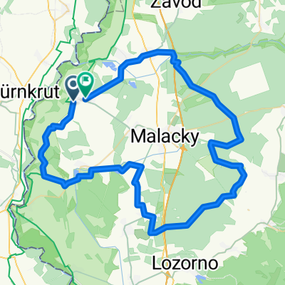
Gajary až Skuteckého, Gajary
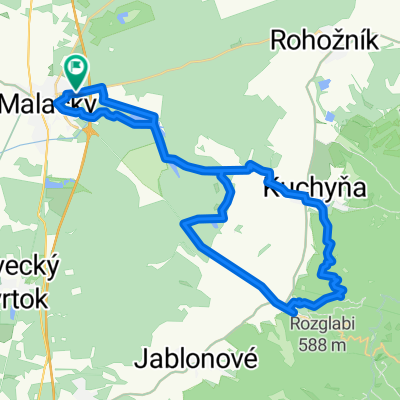
A cycling route starting in Malacky, Bratislava Region, Slovakia.
Overview
About this route
- 1 h 5 min
- Duration
- 13.7 km
- Distance
- 52 m
- Ascent
- 46 m
- Descent
- 12.6 km/h
- Avg. speed
- 159 m
- Max. altitude
Route photos
Route quality
Waytypes & surfaces along the route
Waytypes
Track
10.1 km
(74 %)
Quiet road
2.7 km
(20 %)
Surfaces
Paved
9.3 km
(68 %)
Unpaved
2.1 km
(15 %)
Asphalt
9 km
(66 %)
Unpaved (undefined)
1.4 km
(10 %)
Continue with Bikemap
Use, edit, or download this cycling route
You would like to ride Gajary až Skuteckého, Gajary or customize it for your own trip? Here is what you can do with this Bikemap route:
Free features
- Save this route as favorite or in collections
- Copy & plan your own version of this route
- Sync your route with Garmin or Wahoo
Premium features
Free trial for 3 days, or one-time payment. More about Bikemap Premium.
- Navigate this route on iOS & Android
- Export a GPX / KML file of this route
- Create your custom printout (try it for free)
- Download this route for offline navigation
Discover more Premium features.
Get Bikemap PremiumFrom our community
Other popular routes starting in Malacky
Záhorácka do Záhorácka- Distance
- 12.2 km
- Ascent
- 51 m
- Descent
- 103 m
- Location
- Malacky, Bratislava Region, Slovakia
vyslap 4 - Rudava back home- Distance
- 49.9 km
- Ascent
- 179 m
- Descent
- 143 m
- Location
- Malacky, Bratislava Region, Slovakia
Gajary_Devín- Distance
- 49.2 km
- Ascent
- 61 m
- Descent
- 66 m
- Location
- Malacky, Bratislava Region, Slovakia
Okolo Malaciek - 66 km- Distance
- 66.5 km
- Ascent
- 323 m
- Descent
- 321 m
- Location
- Malacky, Bratislava Region, Slovakia
Cesta mládeže 46, Malacky do Technopol- Distance
- 50.2 km
- Ascent
- 120 m
- Descent
- 138 m
- Location
- Malacky, Bratislava Region, Slovakia
Gajary až Skuteckého, Gajary- Distance
- 13.7 km
- Ascent
- 52 m
- Descent
- 46 m
- Location
- Malacky, Bratislava Region, Slovakia
Šumava 2008:V.Leváre-Černá v Pošumaví- Distance
- 322.5 km
- Ascent
- 2,383 m
- Descent
- 1,973 m
- Location
- Malacky, Bratislava Region, Slovakia
Sturm tour- Distance
- 78.1 km
- Ascent
- 110 m
- Descent
- 121 m
- Location
- Malacky, Bratislava Region, Slovakia
Open it in the app


