

Tour ins Reich der Fischadler
A cycling route starting in Fürstenwalde, Brandenburg, Germany.
Overview
About this route
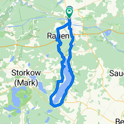
Who has ever seen a real living osprey? In summer, we can observe them around the Gross Schauener lake chain. The tour starts at Fürstenwalde station. Through the city park, we ride along the Spree River to the bridge over the river. On the other side, we must cycle along Rudolf-Breitscheid-Strasse until we reach the lightly trafficked Braunsdorfer Chaussee. In Braunsdorf, we turn left onto Markgrafpiesker Strasse until we hit the Oder-Spree-Tour bike route (OST). We continue left on it to Markgrafpieske. Passing the noteworthy brick church, we then turn left onto Lebbiner Strasse. Via Lebbin and past Lake Lebbiner, we continue straight on through Neu-Boston to Storkow/Mark. First, we pass the children's park Irrlandia, well worth remembering for a day trip with kids. Shortly after, we see peculiar bicycles in a front yard. Here, the "Tour de France Devil" Didi Senft has his museum with all kinds of curious bikes from around the world. In Storkow, we cross a historic drawbridge, ride through the old town, pass Burg Storkow, and reach the large Storkow Lake, inviting for a short swim break in summer. Refreshed, we pedal on quiet paths along the Gross Schauenener See to the Erlebniswelt Fischerei Köllnitz. Here, we can admire the ospreys in their nest. The Sielmann Foundation has installed a camera at an eagle's nest, broadcasting the life of the birds live. The Sielmann Museum also offers much information about the life of ospreys and other animals in the area. The return trip then follows the Didi Senft bike route via Philadelphia, Wolzig (with an impressive root-exposed pine) to Blossin. Now we ride along a forest path to Bindow and continue on the Dahme bike route via Kablow, along Lake Krüpelsee to the Neue Mühle lock. From there, it's not far to Königs Wusterhausen station, where our tour ends.
- -:--
- Duration
- 55.3 km
- Distance
- 69 m
- Ascent
- 74 m
- Descent
- ---
- Avg. speed
- ---
- Max. altitude
Route quality
Waytypes & surfaces along the route
Waytypes
Quiet road
21.6 km
(39 %)
Road
11.6 km
(21 %)
Surfaces
Paved
39.2 km
(71 %)
Unpaved
7.7 km
(14 %)
Asphalt
38.1 km
(69 %)
Ground
2.8 km
(5 %)
Route highlights
Points of interest along the route
Point of interest after 19.3 km
IRRLANDIA der Mitmachpark
Point of interest after 20.6 km
Badestelle. Sehr schön !!
Point of interest after 24.9 km
Wasserbüffel Gehege
Point of interest after 29.2 km
Blick in einen Adlerhorst
Continue with Bikemap
Use, edit, or download this cycling route
You would like to ride Tour ins Reich der Fischadler or customize it for your own trip? Here is what you can do with this Bikemap route:
Free features
- Save this route as favorite or in collections
- Copy & plan your own version of this route
- Sync your route with Garmin or Wahoo
Premium features
Free trial for 3 days, or one-time payment. More about Bikemap Premium.
- Navigate this route on iOS & Android
- Export a GPX / KML file of this route
- Create your custom printout (try it for free)
- Download this route for offline navigation
Discover more Premium features.
Get Bikemap PremiumFrom our community
Other popular routes starting in Fürstenwalde
 Die Tour
- Distance
- 39.3 km
- Ascent
- 442 m
- Descent
- 441 m
- Location
- Fürstenwalde, Brandenburg, Germany
 rund um briesen
- Distance
- 43.1 km
- Ascent
- 94 m
- Descent
- 94 m
- Location
- Fürstenwalde, Brandenburg, Germany
 Radausflug Fürstenwalde 18.06.09
- Distance
- 29.5 km
- Ascent
- 71 m
- Descent
- 71 m
- Location
- Fürstenwalde, Brandenburg, Germany
 Runde Gründheide
- Distance
- 58.9 km
- Ascent
- 356 m
- Descent
- 357 m
- Location
- Fürstenwalde, Brandenburg, Germany
 Oder-Spree-Tour
- Distance
- 236.9 km
- Ascent
- 313 m
- Descent
- 313 m
- Location
- Fürstenwalde, Brandenburg, Germany
 Bf Fürstenwalde-Bad Saarow-Rauen-Fürstenwalde
- Distance
- 47.5 km
- Ascent
- 228 m
- Descent
- 228 m
- Location
- Fürstenwalde, Brandenburg, Germany
 Oder-Spree-Tour
- Distance
- 0.1 km
- Ascent
- 0 m
- Descent
- 0 m
- Location
- Fürstenwalde, Brandenburg, Germany
 Dr-Wilhelm-Külz-Straße, Fürstenwalde/Spree nach Große Tränke, Fürstenwalde/Spree
- Distance
- 4.3 km
- Ascent
- 22 m
- Descent
- 26 m
- Location
- Fürstenwalde, Brandenburg, Germany
Open it in the app