
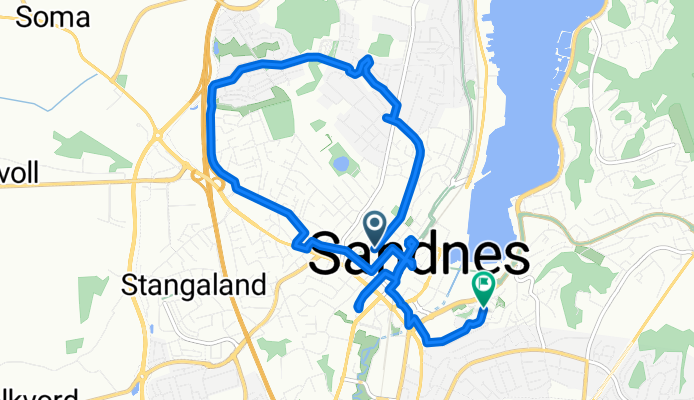
Solaveien, Sandnes to Gravarstunet, Sandnes
A cycling route starting in Sandnes, Rogaland, Norway.
Overview
About this route
- 2 h 41 min
- Duration
- 8.9 km
- Distance
- 98 m
- Ascent
- 99 m
- Descent
- 3.3 km/h
- Avg. speed
- 58 m
- Max. altitude
Continue with Bikemap
Use, edit, or download this cycling route
You would like to ride Solaveien, Sandnes to Gravarstunet, Sandnes or customize it for your own trip? Here is what you can do with this Bikemap route:
Free features
- Save this route as favorite or in collections
- Copy & plan your own version of this route
- Sync your route with Garmin or Wahoo
Premium features
Free trial for 3 days, or one-time payment. More about Bikemap Premium.
- Navigate this route on iOS & Android
- Export a GPX / KML file of this route
- Create your custom printout (try it for free)
- Download this route for offline navigation
Discover more Premium features.
Get Bikemap PremiumFrom our community
Other popular routes starting in Sandnes
 Solaveien, Sandnes to Gravarstunet, Sandnes
- Distance
- 8.9 km
- Ascent
- 98 m
- Descent
- 99 m
- Location
- Sandnes, Rogaland, Norway
 Harfsfjord-Oltedal-Harfsfjord
- Distance
- 69.2 km
- Ascent
- 540 m
- Descent
- 541 m
- Location
- Sandnes, Rogaland, Norway
 Torsdagstur m Sandnes SoS
- Distance
- 71.9 km
- Ascent
- 556 m
- Descent
- 554 m
- Location
- Sandnes, Rogaland, Norway
 CaVerion Base Property rittet lang løype ENDELIG
- Distance
- 77.4 km
- Ascent
- 328 m
- Descent
- 327 m
- Location
- Sandnes, Rogaland, Norway
 Restful route in Sandnes
- Distance
- 44.2 km
- Ascent
- 0 m
- Descent
- 0 m
- Location
- Sandnes, Rogaland, Norway
 Bogafjell, Melsheia og Kleivane
- Distance
- 13.5 km
- Ascent
- 300 m
- Descent
- 302 m
- Location
- Sandnes, Rogaland, Norway
 20-04-2019
- Distance
- 63.6 km
- Ascent
- 633 m
- Descent
- 644 m
- Location
- Sandnes, Rogaland, Norway
 altiplano jæren
- Distance
- 40.5 km
- Ascent
- 632 m
- Descent
- 632 m
- Location
- Sandnes, Rogaland, Norway
Open it in the app