
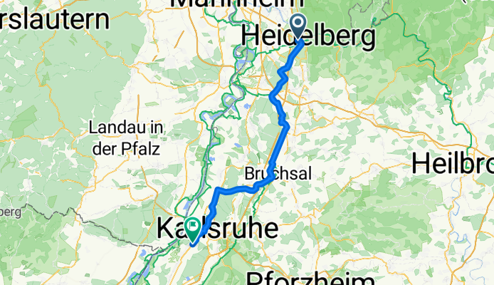
Heidelberg - Karlsruhe
A cycling route starting in Eppelheim, Baden-Wurttemberg, Germany.
Overview
About this route
- 4 h 3 min
- Duration
- 73 km
- Distance
- 252 m
- Ascent
- 243 m
- Descent
- 18 km/h
- Avg. speed
- 125 m
- Max. altitude
Route quality
Waytypes & surfaces along the route
Waytypes
Path
26.3 km
(36 %)
Track
24.1 km
(33 %)
Surfaces
Paved
67.8 km
(93 %)
Unpaved
2.9 km
(4 %)
Asphalt
64.9 km
(89 %)
Gravel
2.9 km
(4 %)
Continue with Bikemap
Use, edit, or download this cycling route
You would like to ride Heidelberg - Karlsruhe or customize it for your own trip? Here is what you can do with this Bikemap route:
Free features
- Save this route as favorite or in collections
- Copy & plan your own version of this route
- Sync your route with Garmin or Wahoo
Premium features
Free trial for 3 days, or one-time payment. More about Bikemap Premium.
- Navigate this route on iOS & Android
- Export a GPX / KML file of this route
- Create your custom printout (try it for free)
- Download this route for offline navigation
Discover more Premium features.
Get Bikemap PremiumFrom our community
Other popular routes starting in Eppelheim
 30.05.2020
- Distance
- 43.9 km
- Ascent
- 507 m
- Descent
- 507 m
- Location
- Eppelheim, Baden-Wurttemberg, Germany
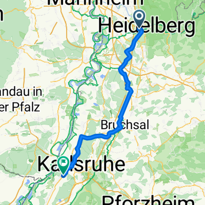 Heidelberg - Karlsruhe
- Distance
- 73 km
- Ascent
- 252 m
- Descent
- 243 m
- Location
- Eppelheim, Baden-Wurttemberg, Germany
 Mannheimer Straße nach Bahnhofstraße
- Distance
- 14.2 km
- Ascent
- 31 m
- Descent
- 69 m
- Location
- Eppelheim, Baden-Wurttemberg, Germany
 Tour de Heidelberg
- Distance
- 61 km
- Ascent
- 1,416 m
- Descent
- 1,419 m
- Location
- Eppelheim, Baden-Wurttemberg, Germany
 Wieslocher Sonntagsrunde
- Distance
- 38.3 km
- Ascent
- 244 m
- Descent
- 230 m
- Location
- Eppelheim, Baden-Wurttemberg, Germany
 Kurzer Odenwaldritt
- Distance
- 29.5 km
- Ascent
- 498 m
- Descent
- 499 m
- Location
- Eppelheim, Baden-Wurttemberg, Germany
 Rennrad Feierabend-Runde
- Distance
- 45.9 km
- Ascent
- 322 m
- Descent
- 319 m
- Location
- Eppelheim, Baden-Wurttemberg, Germany
 100 km Rheinebene
- Distance
- 108.8 km
- Ascent
- 96 m
- Descent
- 95 m
- Location
- Eppelheim, Baden-Wurttemberg, Germany
Open it in the app