

Tour ab Görlitz
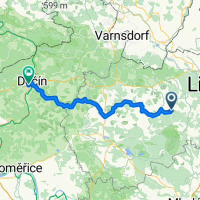
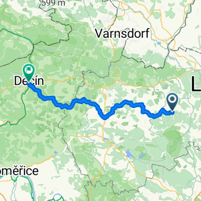
Von Hamr na Jezeře bis Tetschen
A cycling route starting in Stráž pod Ralskem, Liberecký kraj, Czechia.
Overview
About this route
- 4 h 2 min
- Duration
- 69.4 km
- Distance
- 763 m
- Ascent
- 953 m
- Descent
- 17.2 km/h
- Avg. speed
- 393 m
- Max. altitude

Part of
Tour ab Görlitz
5 stages
Route quality
Waytypes & surfaces along the route
Waytypes
Quiet road
21.5 km
(31 %)
Road
20.8 km
(30 %)
Surfaces
Paved
30.5 km
(44 %)
Unpaved
7.6 km
(11 %)
Asphalt
23.6 km
(34 %)
Paved (undefined)
6.9 km
(10 %)
Continue with Bikemap
Use, edit, or download this cycling route
You would like to ride Von Hamr na Jezeře bis Tetschen or customize it for your own trip? Here is what you can do with this Bikemap route:
Free features
- Save this route as favorite or in collections
- Copy & plan your own version of this route
- Sync your route with Garmin or Wahoo
Premium features
Free trial for 3 days, or one-time payment. More about Bikemap Premium.
- Navigate this route on iOS & Android
- Export a GPX / KML file of this route
- Create your custom printout (try it for free)
- Download this route for offline navigation
Discover more Premium features.
Get Bikemap PremiumFrom our community
Other popular routes starting in Stráž pod Ralskem
 Na Lemberk
- Distance
- 28.2 km
- Ascent
- 245 m
- Descent
- 243 m
- Location
- Stráž pod Ralskem, Liberecký kraj, Czechia
 Von Hamr na Jezeře bis Tetschen
- Distance
- 69.4 km
- Ascent
- 763 m
- Descent
- 953 m
- Location
- Stráž pod Ralskem, Liberecký kraj, Czechia
 Ralsko
- Distance
- 84.2 km
- Ascent
- 581 m
- Descent
- 567 m
- Location
- Stráž pod Ralskem, Liberecký kraj, Czechia
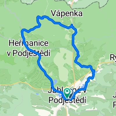 Route to Jablonné v Podještědí
- Distance
- 19.9 km
- Ascent
- 257 m
- Descent
- 257 m
- Location
- Stráž pod Ralskem, Liberecký kraj, Czechia
 Malevil Cup 2010 - Trasa C
- Distance
- 38.2 km
- Ascent
- 781 m
- Descent
- 717 m
- Location
- Stráž pod Ralskem, Liberecký kraj, Czechia
 Von Hamr na Jezeře bis Tetschen
- Distance
- 67.1 km
- Ascent
- 688 m
- Descent
- 874 m
- Location
- Stráž pod Ralskem, Liberecký kraj, Czechia
 Day 25
- Distance
- 53.8 km
- Ascent
- 554 m
- Descent
- 653 m
- Location
- Stráž pod Ralskem, Liberecký kraj, Czechia
 cesta domů
- Distance
- 77.4 km
- Ascent
- 813 m
- Descent
- 1,028 m
- Location
- Stráž pod Ralskem, Liberecký kraj, Czechia
Open it in the app