
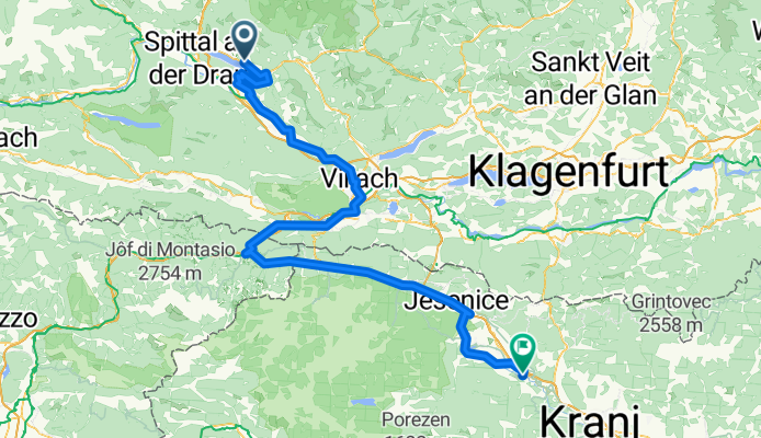
Overview
About this route
- 9 h 2 min
- Duration
- 146 km
- Distance
- 2,717 m
- Ascent
- 2,925 m
- Descent
- 16.2 km/h
- Avg. speed
- 888 m
- Max. altitude
Part of
München - Laibach
5 stages
Route quality
Waytypes & surfaces along the route
Waytypes
Cycleway
75.9 km
(52 %)
Quiet road
38 km
(26 %)
Surfaces
Paved
109.5 km
(75 %)
Unpaved
23.4 km
(16 %)
Asphalt
84.7 km
(58 %)
Paved (undefined)
24.8 km
(17 %)
Continue with Bikemap
Use, edit, or download this cycling route
You would like to ride Jesenice - Laibach or customize it for your own trip? Here is what you can do with this Bikemap route:
Free features
- Save this route as favorite or in collections
- Copy & plan your own version of this route
- Split it into stages to create a multi-day tour
- Sync your route with Garmin or Wahoo
Premium features
Free trial for 3 days, or one-time payment. More about Bikemap Premium.
- Navigate this route on iOS & Android
- Export a GPX / KML file of this route
- Create your custom printout (try it for free)
- Download this route for offline navigation
Discover more Premium features.
Get Bikemap PremiumFrom our community
Other popular routes starting in Millstatt
 Molzbichl nach Molzbichl
- Distance
- 73.4 km
- Ascent
- 1,328 m
- Descent
- 1,379 m
- Location
- Millstatt, Carinthia, Austria
 Molzbichl nach Molzbichl
- Distance
- 55.5 km
- Ascent
- 652 m
- Descent
- 703 m
- Location
- Millstatt, Carinthia, Austria
 Molzbichl nach Molzbichl
- Distance
- 45.3 km
- Ascent
- 1,378 m
- Descent
- 1,429 m
- Location
- Millstatt, Carinthia, Austria
 Molzbichl nach Molzbichl
- Distance
- 46.6 km
- Ascent
- 1,425 m
- Descent
- 1,478 m
- Location
- Millstatt, Carinthia, Austria
 Dráva túra 2. nap
- Distance
- 133 km
- Ascent
- 523 m
- Descent
- 729 m
- Location
- Millstatt, Carinthia, Austria
 Ö-Tour_2016 Kärnten_Etappe
- Distance
- 154.9 km
- Ascent
- 1,673 m
- Descent
- 543 m
- Location
- Millstatt, Carinthia, Austria
 Matzelsdorf-Laufenberg
- Distance
- 33 km
- Ascent
- 1,431 m
- Descent
- 1,423 m
- Location
- Millstatt, Carinthia, Austria
 Lechnerschaft 661/1 nach Lechnerschaft 661/1
- Distance
- 29.3 km
- Ascent
- 408 m
- Descent
- 406 m
- Location
- Millstatt, Carinthia, Austria
Open it in the app