
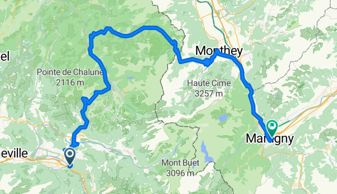
GTJR6bis_Cluses-Encrenaz-Mey_My
A cycling route starting in Cluses, Auvergne-Rhône-Alpes, France.
Overview
About this route
- 6 h 43 min
- Duration
- 107.5 km
- Distance
- 3,118 m
- Ascent
- 3,134 m
- Descent
- 16 km/h
- Avg. speed
- 1,440 m
- Max. altitude

Route quality
Waytypes & surfaces along the route
Waytypes
Road
36.6 km
(34 %)
Quiet road
19.4 km
(18 %)
Surfaces
Paved
75.3 km
(70 %)
Asphalt
75.3 km
(70 %)
Undefined
32.3 km
(30 %)
Continue with Bikemap
Use, edit, or download this cycling route
You would like to ride GTJR6bis_Cluses-Encrenaz-Mey_My or customize it for your own trip? Here is what you can do with this Bikemap route:
Free features
- Save this route as favorite or in collections
- Copy & plan your own version of this route
- Split it into stages to create a multi-day tour
- Sync your route with Garmin or Wahoo
Premium features
Free trial for 3 days, or one-time payment. More about Bikemap Premium.
- Navigate this route on iOS & Android
- Export a GPX / KML file of this route
- Create your custom printout (try it for free)
- Download this route for offline navigation
Discover more Premium features.
Get Bikemap PremiumFrom our community
Other popular routes starting in Cluses
![Cluses to Cully via Thonens [ferry 18km]](https://www.bikemap.net/media/temp/routes_gallery/4b510814-05f9-4722-aaf8-b25c05cc8fd2.png) Cluses to Cully via Thonens [ferry 18km]
Cluses to Cully via Thonens [ferry 18km]- Distance
- 87.1 km
- Ascent
- 2,063 m
- Descent
- 2,170 m
- Location
- Cluses, Auvergne-Rhône-Alpes, France
 GTJR6ter_Cluses-Mey_My
- Distance
- 108.3 km
- Ascent
- 2,799 m
- Descent
- 2,816 m
- Location
- Cluses, Auvergne-Rhône-Alpes, France
 *XX-?. Cluses - Croix de Dormiaz (Km 147)
- Distance
- 146.9 km
- Ascent
- 5,075 m
- Descent
- 3,985 m
- Location
- Cluses, Auvergne-Rhône-Alpes, France
 XX-D. Cluses - Col des Annes (Km 133)
- Distance
- 132.9 km
- Ascent
- 4,503 m
- Descent
- 3,260 m
- Location
- Cluses, Auvergne-Rhône-Alpes, France
 Cluses-Ramaz-Encrenaz-Joux Plane-Cluses
- Distance
- 96 km
- Ascent
- 2,136 m
- Descent
- 2,136 m
- Location
- Cluses, Auvergne-Rhône-Alpes, France
 2. Etappe Genf - Nizza
- Distance
- 91 km
- Ascent
- 2,406 m
- Descent
- 2,406 m
- Location
- Cluses, Auvergne-Rhône-Alpes, France
 Cluses - Plan des Fontainettes
- Distance
- 200 km
- Ascent
- 4,853 m
- Descent
- 3,247 m
- Location
- Cluses, Auvergne-Rhône-Alpes, France
 2019-05-30 / Alpes - Cluses / Cols de la Ramaz, de l'Encrenaz, des Gets et de Chatillon
- Distance
- 79.5 km
- Ascent
- 1,638 m
- Descent
- 1,638 m
- Location
- Cluses, Auvergne-Rhône-Alpes, France
Open it in the app