
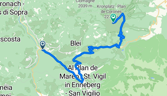
PLA DE CORONES-KORNPLATZ
A cycling route starting in San Vigilio, Trentino-Alto Adige, Italy.
Overview
About this route
El Pla de Corones (Kronplatz), situated in the heart of South Tyrol, is one of the most unique and challenging giants in the alpine cycling panorama. Its summit, crowned by a plateau of ski slopes and an imposing panoramic structure, has been the protagonist of some of the most spectacular days of the Giro d'Italia, especially since 2008 when it was included as the finish of an individual time trial, forever etched in memory for its mix of extreme gradients and gravel surface in the last kilometers.
- 1 h 49 min
- Duration
- 17.2 km
- Distance
- 1,393 m
- Ascent
- 154 m
- Descent
- 9.5 km/h
- Avg. speed
- 2,273 m
- Max. altitude

Route photos

Route quality
Waytypes & surfaces along the route
Waytypes
Track
3.4 km
(20 %)
Access road
1.9 km
(11 %)
Undefined
11.9 km
(69 %)
Surfaces
Paved
1 km
(6 %)
Unpaved
5.5 km
(32 %)
Gravel
3.1 km
(18 %)
Unpaved (undefined)
1.9 km
(11 %)
Continue with Bikemap
Use, edit, or download this cycling route
You would like to ride PLA DE CORONES-KORNPLATZ or customize it for your own trip? Here is what you can do with this Bikemap route:
Free features
- Save this route as favorite or in collections
- Copy & plan your own version of this route
- Sync your route with Garmin or Wahoo
Premium features
Free trial for 3 days, or one-time payment. More about Bikemap Premium.
- Navigate this route on iOS & Android
- Export a GPX / KML file of this route
- Create your custom printout (try it for free)
- Download this route for offline navigation
Discover more Premium features.
Get Bikemap PremiumFrom our community
Other popular routes starting in San Vigilio
 St. Vigil - Sella Runde - St. Vigil
- Distance
- 106.1 km
- Ascent
- 2,907 m
- Descent
- 3,000 m
- Location
- San Vigilio, Trentino-Alto Adige, Italy
 Giro 2010 16. Etappe: San Vigilio di Marebbe - Kronplatz (BZF)
- Distance
- 13 km
- Ascent
- 1,087 m
- Descent
- 92 m
- Location
- San Vigilio, Trentino-Alto Adige, Italy
 Kronplatz zum Messnermuseum
- Distance
- 4.3 km
- Ascent
- 523 m
- Descent
- 37 m
- Location
- San Vigilio, Trentino-Alto Adige, Italy
 Extremtour Von St. Vigil nach Prags CLONED FROM ROUTE 401608
- Distance
- 52.6 km
- Ascent
- 1,861 m
- Descent
- 1,862 m
- Location
- San Vigilio, Trentino-Alto Adige, Italy
 GK_Anschlusstour 2016, Etappe 3d
- Distance
- 74.6 km
- Ascent
- 951 m
- Descent
- 1,206 m
- Location
- San Vigilio, Trentino-Alto Adige, Italy
 La Crusch
- Distance
- 50.7 km
- Ascent
- 1,882 m
- Descent
- 1,882 m
- Location
- San Vigilio, Trentino-Alto Adige, Italy
 DOLOMITI 4
- Distance
- 85.6 km
- Ascent
- 1,804 m
- Descent
- 1,712 m
- Location
- San Vigilio, Trentino-Alto Adige, Italy
- PLA DE CORONES-KORNPLATZ
- Distance
- 17.2 km
- Ascent
- 1,393 m
- Descent
- 154 m
- Location
- San Vigilio, Trentino-Alto Adige, Italy
Open it in the app